68 High Street
History
No68
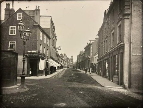
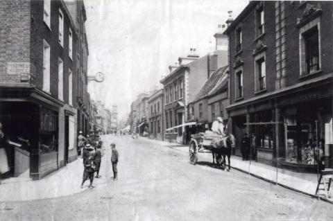
In 1865 the shop was run by William Harmer as a Linen Draper and by 1900 it had been taken over by William Myhill Chapman who was also a Draper. In Kelly's Directory of 1932 it has Samuel Fowler, also a draper at no68. After G. L. Crisp, Newsagent was bombed during the Second World War it relocated to this address. When the 2nd picture was taken in 1998 the shop was Sugar Art World, Cake decoration and sugar craft equipment. Now in 2016 Ultimate Boxing and Fitness Gym has moved in.
No69
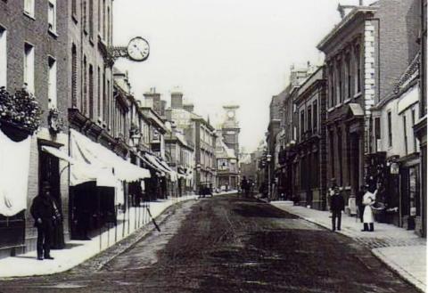
No69 is built on the site of the once Angel Inn which stood here from the 15th to the 18th Century and until the 1970's it had a connection to alcohol because until then it was an off-licence. First it was a Lacon off-licence and then in 1967 Diver and Son was running a Wine and Spirit Merchant, the 3rd picture was taken in 1998 where you can see it is the Royal Bengal Indian Restaurant. Now in 2016 the shop is a boxing shop, boxing gym equipment and event tickets connected with Ultimate Boxing.CREDIT: Lowestoft High Street, The Butcher, The Baker and The Candlestick Maker by Crispin Hook 2016 Get the book
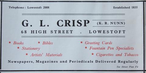
Crisp's Stationers and Bookshop advert from Lowestoft Corporation Street Map circa 1954
Architecture
The site of Nos. 64-69 HIGH STREET - occupied by two sets of mid-late 19th century, terraced, triple shop-builds of differing style - was originally one of the largest burgage-plots on the eastern side of the highway (stretching down to Whapload Road) and once occupied by an inn called “The Angel”. During the late 15th and early 16th century, it had belonged to the Hatter family - whose members were among the richest merchants in the town. There are then no details as to ownership until the early 17th century, when Robert Keble and John Nolloth (non-resident gentlemen), who had acquired the property at some point, sold it in April 1605 to William Crowe (another non-resident member of the gentry). Following his death, it passed to his son Parker in September 1614 and then to another son (named William) in March 1615, following the death of the said Parker. Two and a half years later, in September 1617, it was purchased by William Kettleborough - another gentleman, who must have moved into town after acquiring the premises since a parish register entry of 21 November 1619 records the baptism of a daughter Mary born to him and his wife (also Mary).
No further baptisms follow and the property remained in his occupancy, until he disposed of it to his son, Francis, and daughter-in-law to be, Mary, in November 1646 (whether by gift or sale is not known). It could possibly have been a marriage gift, as Francis Kettleborough and Mary Hawes were actually married on 10 December 1646. And it was they who began subdivision of the messuage, in August 1651, when they sold the land now occupied by Nos. 64 & 65 and by No. 66 as house-plots, respectively, to Francis & Amy Canham and to Nicholas & Mary Pye - both of these men being mariners/fishermen. The land on which Nos. 67, 68 & 69 now stand was sold in January 1657 to William & Alice Rising - a Dissenting [Nonconformist] merchant and his wife, who built two houses upon it. They lived in the first one, near to an entry-way (still remaining in place and appearing to have been built over, probably during 19th century reconstruction work), which can therefore perhaps be associated with the present-day No. 67.
But only in part. Given that the land now taken up by three shops was occupied by just two dwellings in 1657, the Risings’ house was certainly larger than the single unit of No. 67 today. And, in any case, it is not clear from the manorial records exactly how the two buildings were placed since there is reference to one being nearer to the High Street than the other. The main thing of interest regarding the Risings’ home is that it was licensed for legal Dissenting worship in May 1672 and served that purpose until the town’s Dissenting Chapel was built, in 1695, immediately next door to the site now occupied by Nos. 127 & 128 High Street. Prior to that, the local Nonconformist population had met for illicit Christian services in a barn (owned by the Pacy family) abutting onto the Market Place, on the south side of Blue Anchor Lane [Duke’s Head Street].
William Rising’s widowed daughter-in-law, Susan, was still living in the family home in 1725, while the other dwelling had obviously been rented out to tenants since it was built. Details of only one of them turns up in the manor court records: a fishing-boat master, called Henry Blackman, who died in a drowning accident in the Spring of 1706. His burial entry of 12 May, in the parish register, reads thus: “Henry Blackman, who joking with the next person following under sail in the North Road both fell overboard into earnest eternity (a fair cavett [sic] to others not to do the like). They were taken up the week following and buried etc.” There is no specific, named reference to the other victim. Neither man would have been able to swim, in typical fashion of the time, and a few days would have elapsed before their bodies were washed ashore.
The burial entry of William Kettleborough, after whose tenancy major changes to “The Angel” messuage occurred, is also to be found in the parish register - on 2 November 1658. It reads thus “Will: Keatleborough, an honist ould gent”. But those changes, recorded in detail above, did not see the end of the Kettleborough connection with the original plot. The family retained ownership of land to the east of the High Street houses which had been built, set at lower levels on the terraces - and, on the upper one of these, stood a substantial dwelling subdivided into two separate units, both of which were accessed from Rant Score. Francis Kettleborough (William’s son) and his wife lived in one half, while the other moiety seems to have been rented. In 1725, Alice Kettleborough was in possession. She was the great-great-granddaughter of the earliest William - via her father Francis 2, who was son of William 2 (mariner), who was the son of Francis 1 (seaman), who was the son of William 1. The other part of the dwelling has reference made to a tenant called Elizabeth Westgate - without there being any specific time of occupancy given. She was probably the Elisabeth Wesgate, widow, whose burial is recorded in the parish register on 3 February 1684.
And that is about as much as can be said, going on information I have managed to gather over the years from the town’s parochial and manorial documentation - mainly covering the late 16th century to about the the third decade of the 18th. One further comment is perhaps permissible, regarding how William Kettleborough 1’s son Francis did not continue with his father’s social status of gentleman, but turned to a life at sea (a combination, probably of maritime trade and fishing) and was followed in this by his own son, William. The likelihood for this is that William Kettleborough 1 was on the downward path economically - for whatever reasons - and already coming to the end of the social line. CREDIT: David Butcher
We're standing at the top of Rant's Score looking north, possibly or probably one of the oldest existing photographs of the area. If you look carefully we can indicate that to you the background there you can see right up here where the Town Hall would eventually be built you can see what appears to be a small tower. That's almost certainly the cupola of the Old Town Chamber that was demolished in 1859-60 to build the Town Hall. So, this picture is possibly as early as 1859-60. So we're looking up and we can see that as we look both through the pictures you can see how it's evolved. Just to put a context to the whole thing, this building here is what would become Barclays Bank.
Many of these properties, these low, mean properties, have disappeared as we shall see. If we look next to the bank, to the south of the bank, two small little cottages. Those would disappear by the time we come to the next photo. This is looking up much later. And you can see here the Town Hall is now being built where the Town Chamber once was.
And you can see that the buildings on the west side are far bigger and more elaborate than in the earlier picture. On the left hand side and here is the bank and here where I mentioned there was two rather mean, small buildings they've disappeared and this grandiose building has been built. One big house taking up the plots of two properties, and this was built for one of the wealthiest families in Lowestoft, the Youngman family who were wealthy brewers. In my opinion what we're looking at here is as Lowestoft grew in the 19th century, the fishing fleet got bigger, more and more industry came to town, more and more people came to town, the town certainly started to become much wealthier and it's reflected in the style of the buildings.
I should say this picture is early 1870s. We know that these properties on this side, these low properties here were probably erected in 1876 with big three, four storey Italianate style buildings, so these have all gone. The photographer told them if they were moving, they'd all come out as blurs. I wouldn't be surprised if that's not a mother. And two daughters to be honest with you. The other thing that's always interesting, we've looked at others... again this picture is taken on a very bright sunny morning, judging by... east is to the right of the picture. Judging by the strong shadows, the sun is well in the east and this is quite an early morning picture. But once again all of the shop fronts have put their awnings out to protect their goods from the strong sunshine. CREDIT: Ivan Bunn from transcript - Poetry People - High Street Histories
Surviving internal timber framing
One small length of mid-16th century beam/joist, with scrolling vine-leaf motif, once visible on the right hand side of the shop space, towards the back of it. The site of Nos. 64-69 was once occupied by a large inn called The Angel, whose messuage underwent subdivision during the 1650s. CREDIT:David Butcher


Add new comment