
Eras
Visit our new project Our Fallen. This section includes Wartime, Pre-History and Medieval. Try the Wartime Timeline to look at some key dates in our history
What you see is the remains of the base of a beacon, one of a pair erected in 1552 (on the orders of the Marquis of Northampton), to warn of attack from the sea. Its companion was located just to the north of what is now the junction of Gunton Drive with Corton Road.
Added: 22 September, 2023
This building, which stands in Arnold Street, is in need of some restorative tlc and is an important remnant of Lowestoft’s military past. Built and opened in 1872 for the Lowestoft Artillery Volunteer Company which (along with accompanying Rifle Volunteers) was formed in 1860. Designed by local architect W.O. Chambers.
Added: 22 September, 2023
Kirkley Cemetery is a burial ground in the Kirkley area of Lowestoft in Suffolk. Located on London Road South, the cemetery is maintained by Waveney District Council and is open for traditional and Green Burials. Thr two Memorial Chapels were designed by local architect J.L. Clemence in Early English gothic style.
Added: 22 September, 2023
All of the older names listed below in italic font derive from documentation of one kind or another relating to the town – particularly those manorial records recording the transfer of property 1582-5 & 1616-1756, to the Revd. John Tanner’s transcriptions of these done up until 1720-25, and to the Manor Roll of 1618. All found as Suffolk Archives (Ipswich), 194/A10/4, 194/A10/ 5-19, 454/2 and 194/A10/73.
Added: 20 June, 2026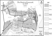
One of the most interesting features of local landscapes during the Late Medieval and Early Modern periods in any community (and Lowestoft was no exception) was the presence of areas not used for agriculture – usually because the soil was unsuitable for crops or too difficult to work, for one reason or another – and being generally referred as either common or waste. The former term referred to the land being available to people for various kinds of use and the latter derived from the Latin word vastus, meaning “empty” or “open”.
Added: 19 May, 2026
Faith and Duty opposing Earthly Ambition - A Local Story
Introduction
Added: 17 April, 2026
(LT 649)
If upon your port is seen
A little German submarine,
Do not fire shot nor shell.
Just turn around and run like hell!
(Fishermen’s parody of a navigation rhyme)

Tape-recordings made 1976-83
The recordings were made with local people, with the intention of producing a sound archive to record an important part of the Lowestoft area’s industrial and maritime history. They form the basis of six published works: The Driftermen (Reading, 1978), The Trawlermen (Reading. 1979), Living From the Sea (Reading, 1982), Following the Fishing (Newton Abbot, 1987), Fishing Talk (Cromer, 2014) and The Last Haul (Lowestoft, 2020).
Added: 11 March, 2026
“I know not whether laws be right,
Or whether laws be wrong.
All that we know who lie in gaol
Is that the wall is strong;
And that each day is like a year,
A year whose days are long.”
(Oscar Wilde: “The Ballad of Reading Gaol”)
, executed by Richard Powles in 1782. This was the town’s multi-purpose civic HQ until the Town Hall was built (1857-60), with the curfew bell hung in the cupola surmounting the roof. Suffolk Archives (Ipswich), 193/2/1 - the Isaac Gillingwater collection of illustrations (c. 1807).")
The pages reproduced below, in as near as possible their original format, are to be found in volume 3, section 4, of Robert Reeve’s four volume manuscript ‘A History of Lowestoft and Lothingland’ (c. 1810) – Suffolk Archives (Ipswich), 193/3/4. Nothing is recorded for the years 1719, 1722, 1728 and 1733. Reeve (a local solicitor), who lived at No. 49 High Street, was steward of the manor and he must have transcribed this material from an original source of some kind.
Added: 2 March, 2026