
AREAS and TYPES

Although not new this needs to be monitored and also brought to the attention of the groups interested in maintenance of the Scores
Added: 23 September, 2023Name: Old Lowestoft Scores Trail
Difficulty: Hard - several sets of steep steps. Not suitable for mobility scooters, prams, push chairs
Length: 2.5k (1.6 miles)
Terrain: Steps, pavements, paths, crossing roads
Summary: The walk follows most of the Lowestoft Scores (and passes or crosses them all).The map is interactive. Scroll down for text, photos and video clips.
Added: 23 September, 2023

North Lowestoft Heritage Action Zone "The North Lowestoft Heritage Action Zone (HAZ) covers Lowestoft High Street and Scores, the Sparrow’s Nest Park and the Whapload Road area. The aim of the HAZ is to promote the renovation and repair of historic buildings and public spaces to stimulate the economic revival of the area.
Added: 23 September, 2023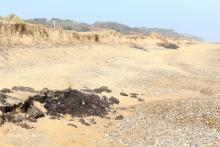
East Suffolk Council have announced (23/2/21) they will clear the exposed lumps of fuel oil previously buried in 1978 on North Beach, and will try to work out what to do next. They think that the oil may be more liquid in the bigger deposits. Anglian Water sewerage pipes run underneath the dunes, which is a further problem. ESC are adamant they are closely monitoring the situation.
Questions about the Eleni V oil on North Beach are ramping up. Local politicians are asking when something is going to be done. Social media is doing its strident thing.
Added: 23 September, 2023
The crime scene is at the junction of Links Road with Gunton Cliff (was Esplanade). A tree has been neatly felled. The illegal, as described by Lowestoft Town Council, tree removal has caused much consternation. LTC have acted fast. The police are investigating.
Smaller trees have been removed nearby, as well. The trees are probably self-set sycamores.
The felling took place in Gunton Ward, which is bounded on the south by The Ravine.
Added: 23 September, 2023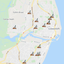
One of the key features of this site is its ability to turn all content (that relates to a location) into a dynamic map and then filter it to show similar content together.
For example we have information about allotments. So if you go to the web address https://lowestoftoldandnow.org/full/maps/ BUT then add allotments at the end
https://lowestoftoldandnow.org/full/maps/allotments you will see (have a guess!)
Added: 23 September, 2023
At the junction of St Peter's Street and the High Street there's a big sign saying 'Pedestrian Zone'. It looks quite clear to me but cars regularly pass by it. There were two signs but one of the signs was removed about a couple of weeks ago. Don't know why, or by whom.
The cars, the vans, even the bicycles, in that triangular area and down the road have long caused problems to people who foolishly think that when a big official sign says 'Pedestrian Zone' that's what it means.
Added: 23 September, 2023
Use It All, Lowestoft Old and Now Community Website, Food Savvy/Suffolk Recycle, Most Easterly Community Group, Friends of Dip Farm and Lowestoft Town Council all had stalls under the Triangle Sails on Saturday the 18th September 2021.
Lowestoft Heritage Open Days Week seems to have been a tremendous success, again. An amazing amount of effort and work put into it right across Lowestoft, mostly by volunteers. An astonishing 115 events were listed.
Added: 23 September, 2023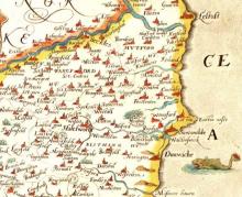
Christopher Saxton map showed Easton Ness as the most easterly point of Great Britain. Over the next decades, the action of the sea caused the salient to migrate north, to Lowestoft Ness.
Added: 23 September, 2023