
Sea
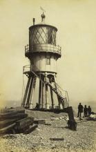
1923 Low Light extinguished, as the Stanford Channel was no more.
Added: 23 September, 20231881 Low Light now also flashes. And had to be moved 80 yards inland, because of erosion.
Added: 23 September, 20231872 - 74 The present High Light was built. It had a new optical revolving light, flashing at half-minute intervals.
Added: 23 September, 2023")
At the Norfolk and Suffolk Coast and Estuary Conference on 15th October in the Orbis Energy Centre Peter Aldous MP had some critical things to say about 'Central Government' (which is his government since 2010).
He said “...governments – whether it's wind-farms or solar farms, or dare I say it, fracking, governments impose these things on communities... but governments shouldn't work with communities, communities should lead projects.”
Added: 23 September, 2023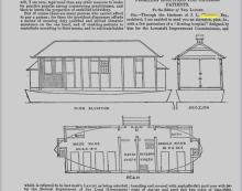
Designed by John Louth Clemence
the Editor of Ths LANCET.
But of course there are many persons who cannot afford to pay a guinea; for them the provident dispensary affords
SIR, -Through the kindness of J. L. Clemence Esq.,
a means of securing duly qualified and skilled obstetric architect, I am enabled to send you an elevation, plan, &c., assistance on the one hand, and of enabling patients to contribute according to their means, and to cultivate habits
Added: 23 September, 2023
What’s the best way to find out?google maps traffic live link
Also this is what ABP told us
===
Hi Joe,
We apply for road space and closures using national highways online booking portal.
Once those applications have been approved the Road closure information is then uploaded to the one network site.
Information link - https://uk.one.network/communicate/onenetwork-map
Live map link - https://one.network/
Added: 23 September, 2023
The harbour was originally built by the Lowestoft and Norwich Navigation Company and developed by the Norfolk Railway following the construction of the Norwich to Lowestoft railway.[4] The original Inner Harbour was constructed in 1831 when Lake Lothing was joined to the sea, as shown on a chart based on a survey by William Hewett of HMS Fairy dated 1834,[5] while the Outer Harbour was constructed in 1937.[4] The railway line ran along the north side of the docks and a series of docks railway sidings were used mainly for fishing and freight wagons.
Added: 22 September, 2023
Looking southwards, along the North Sea Wall, to Ness Point - the most easterly part of the UK mainland. The presence of the Gulliver wind-turbine and the Orbis Energy Centre building just beyond it reminds us of Lowestoft’s role in the new world of renewable supplies of electricity - though it seems ironic that the turbine itself never seems to have its blades turning sufficiently to make any notable contribution to the National Grid.
Added: 22 September, 2023
A different kind of warning light from that referred to in Beacon Stones, with safety at sea the main consideration rather than warning of attack by an enemy.
Added: 22 September, 2023