
Relocation of the Township (c. 1300-1350)

Reasons for the move
It is perhaps unwise to single out any one particular event in the life of a community over a period of about 1,500 years as being the crucial or formative one (other than its founding), but there is a good case for doing so where Lowestoft is concerned. The change of location for the town, from its original site (loosely, in the north-eastern sector of what is now the municipal Normanston Cemetery) to one slightly less than a mile to the east-north-east was of key importance in its subsequent development, as this allowed it to take advantage of both the land-based and maritime opportunities that were available to it. The cliff-top position was bleaker and more exposed to the elements than its predecessor, but it gave the local people greater flexibility in more conveniently pursuing a range of economic activities based on the products of land and sea.
Both the Domesday Survey (1086) and the Lothingland Hundred Roll enquiry (1274) give the sense of a place founded on, or grounded in, agriculture – and there is no doubt that the soil was instrumental in feeding the population and providing it with a range of materials with which to make many of the necessary utensils and tools required to maintain a basic standard of living. Yet the ocean was only a short distance away and it, too, was capable of both providing food and creating a highway on which all kinds of goods and commodities could be conveyed both inwards and outwards. Given the way that herrings shoaled close to shore in both the autumn and the spring, they would certainly have been netted by small boats working off the local beach – and other species too, both pelagic and demersal, would have been caught by either net or line at other times.
There is no direct reference to fish or fishing in the Domesday information relating to Lowestoft, though Gorleston is recorded as having twenty-four fishermen who worked in Great Yarmouth, but who belonged to the Lothingland manor. And there is ample evidence as to the catching of herrings locally to be found in data relating to Mutford Half-hundred. A number of its manors (both coastal and inland) paid herring rents of varying value to the lord, Hugh de Montfort, who probably took quantities of salted fish to supply his household. Further down the coast, Southwold paid an annual toll of 25,000 fish to the Abbey of Bury St. Edmunds, while the inland town of Beccles was levied at 60,000 to the same institution. With something like 800-1000 fish per barrel, it can be seen that catches were small in scale compared with later times, but the potential was there to increase the scope of the operation for markets at home and abroad.
Nothing has been found in any documentation to prove that Lowestoft changed its location from the original one for specific maritime considerations. However, it would have made sense for the community to relocate to the position adopted, so as to be more conveniently situated for the pursuit of sea-related activities. It is evident that, during the 13th and 14th centuries, Great Yarmouth was sensitive regarding the economic aspirations of its Lothingland neighbours and determined to maintain what it saw as its primacy in local fishing and maritime trade. Gorleston, on its own doorstep, was the community most likely to have been seen as a threat initially, but as Lowestoft emerged as a significant force in the governing structure of Lothingland during the second half of the 13th century and the first half of the 14th, it too would have come under Yarmouth’s scrutiny.
Lothingland Half-hundred in the 14th century
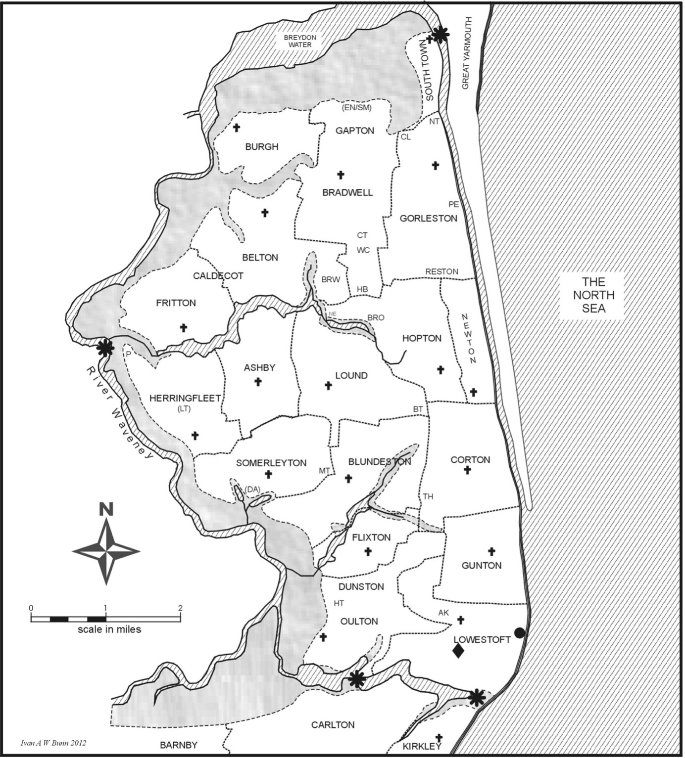
• The black lozenge indicates Lowestoft’s original location; the black circle, the one it moved to.
• The four black asterisks indicate river crossings.
• Crosses represent the presence and location of parish churches
• Lesser settlements are represented by initials and are identified as follows. AK (Akethorp) – BRO (Brotherton) – BRW (Browston) – BT (Boyton) – CL (Claydon) – CT (Carlton) – DA (Dale) – EN (Enges) – HB (Hobland) HT (Houghton)– LN (Lanthorp) – MT (Manthorp) – NE (Ness - the) – NT (Northtown) – PE (Peneston) – SM (Smallmoor) – TH (Thorp) – WC (Wheatcroft).
Other than the need to occupy a more suitable site for the pursuit of fishing and maritime trade, it is also possible that the grant of a market and fair to the town in 1308 had a part to play in its relocation. The point can be made that there may not have been a suitable site in, or near, the established township on which to stage the two events – and so a new venue would have been needed. It is also possible that rising sea levels at this time, together with periodic catastrophic tidal surges occurring c. 1275-1340 (both of which may have combined to cause flooding of the South Norfolk peat-diggings and create The Broads) had caused the former inlet on Lake Lothing (in line with the bottom of what is now Rotterdam Road) to revert to an earlier state and cause inconvenience near the centre of population with increasingly saturated land to the south of it. Thus, it would have made sense to seek somewhere better drained, which offered fresh opportunities for expansion of the community in both economic and demographic terms.
A further factor worthy of consideration is the increase in the size of Lowestoft’s population during the 12th and 13th centuries. This was about seventy-five people at Domesday (1086) and an estimate of c. 200-250 people (from data in the 1274 Lothingland Hundred Roll) may have been sufficiently high in number (if true) to create the need for a different location in which to provide adequate space for an expanding number of inhabitants and dwelling-houses. This would have been particularly the case if the original township site was constrained in its ability to grow larger because of its position at the meeting-point of the two, larger, arable common fields, with track-ways to the north, east and south of it. Intrusion into arable land would not have been welcome and there was no structured, linear layout, as at Gorleston, to allow (even encourage, perhaps) the spread of cottages and outbuildings. What has been termed “rural congestion” had reached a peak countrywide by the beginning of the 14th century (set against a backdrop of poor harvests during the first two decades), which therefore places Lowestoft in a national context at the time it relocated itself.
Furthermore, an increasing population would have eventually needed economic activity beyond mere subsistence and local service to enable it to flourish. The sea offered the best chance of being able to do this; so, if the town was to expand, it would have to do it somewhere else. And, in any case, a process of proto-urbanisation may already have begun in what had been an essentially rural community. There is slender evidence that Lowestoft may have been changing in nature by the end of the 13th century and the earlier part of the 14th. The Hundred Roll record, for instance, reveals tenant surnames (as we would now call them) which refer to or imply specific areas of occupation: metal fabrication, woodworking, milling, peat-digging, making casks, building carts and the cutting of furze (gorse), bracken and scrub. Obviously, all of them relate to the land in one way or another, but they were not exclusive to the practice of husbandry and had relevance to areas of activity other than agricultural ones. Fifty years later, the national 1327 Lay Subsidy information reveals the presence of someone involved in supplying the luxury end of the domestic market (a candlemaker), as well as a certain degree of inward population migration from both close at hand and further afield – a feature associated with urban development of the time.
At the same time as this modestly increasing diversity in land-based activity was developing, a range of occupations associated with the sea would also already have emerged. The autumn herring season would have been the prime area of interest, with the catching and processing of fish (the latter involving the community’s women, to a certain degree) of some significance in the local economy. Added to this would have been the necessary ancillary tasks which serviced and underpinned the fishing operation itself, particularly the manufacture and maintenance of nets and the construction of vessels in which to put to sea. The former area would almost certainly have made use of female labour, while the latter would have extended the range of work available to men with wood- and metal-working skills. Cartage would also have been required to move the freshly caught fish from the shoreline to the inland location of the township – unless, of course, curing facilities had already been established in the beach area itself.
The new site
It is clear from details to be found in a series of surviving court baron extracts, relating to the streets and buildings of the early 18th century town, that it had originally grown up on what had (up until the move from the earlier site) been coastal heathland. The term “a messuage (or cottage) from thewaste of the lord” is periodically encountered in the description of individual plots, leaving the reader in no doubt as to their origins. The document cited is a near-complete sequence of transfer, from c. 1600 onwards to 1725, relating to every copyhold tenement in the town (c. 85% of the houses and ancillary buildings). It was compiled by the Revd. John Tanner (vicar of the parish, 1708-59) between 1720 and 1725 – his position as local priest and chief tenant of the manor giving him access to the records – and it is a primary source of inestimable value. See Suffolk Archives (Ipswich), 454/2.
The light, sandy topsoil referred to would have been covered naturally in bracken, gorse, thorn and scrub birch, and the area (like others of its kind in the parish) would have been used for the rough grazing of livestock and the exploitation of useful materials. It must at one time have been a cliff-top stretch linking the North Common and its southern counterpart, with both the North Field and the South Field making major intrusions into it as some of this marginal land was put under the plough during the Early Medieval period – and almost certainly earlier than that in places. It may not have been of the most fertile nature, but it was easily workable and capable of growing a range of crops.
The edge of this cliff-top area was the site chosen on which to relocate the community of Lowestoft, and it had a number of features to commend it. It was close to the beach and therefore able to offer convenience of operation where fishing and other maritime pursuits were concerned. Access was made possible by a number of deeply cut rainwater drainage-channels in the cliff-face (known as scores), which could be used as footways, and much of the beach’s surface was covered in low shrubbery and scrub grass enabling it to be traversed more easily than either sand or shingle. The light nature of the cliff-top’s surface soil meant that it drained easily – a process that was aided by a slope in the land, falling from north to south (with a lesser drop from west to east) – and the clay layer beneath acted as a moisture-trap, which could be accessed by the sinking of wells to provide supplies of water. Admittedly, the bulk of the arable farmland was now further away than it had formerly been, but this in itself may suggest a recognition that the town’s future lay more with the sea than with the land and that maritime pursuits would increasingly become the community’s defining feature.
There was at least one overriding advantage to the lord of the manor in sanctioning relocation of the township round about the year 1300. Whether it was Edward I or his nephew and successor, John de Dreux, is not known (it could have been either), but it must surely have been brought to either man’s attention by the manor’s steward, or bailiff. And he, in turn, would have been responding to the wishes of the people (or, at least, to those of their leaders, the manorial chief tenants) in requesting such a major change. And there is no denying that there was money in it for the lord. The area of heathland chosen for the new town-site would have brought in a certain return, in its undeveloped state, in the form of fees charged for rough-grazing rights and the taking of materials. But it would not have amounted to much. Turning the ground over to building houses would have raised cash from the initial sale of the land, with an ongoing and regular income assured from having the different properties regulated by a form of customary tenure whereby an annual rent was paid to the lord (based on the size of the dwelling and its plot) and an entry finelevied on each new tenant as he or she took over the messuage.
The best guess as to the purchase of the land in the first place is that the wealthier members of the community, men such as William Reynald and his like, pooled their resources and carried it out with the assistance of the manor’s steward, buying as much ground-space as was needed and leaving future acquisition(s) to take place as required. The 1618 Manor Roll – Suffolk Archives (Ipswich), 193/A10/73 – reveals that the 203 copyhold properties in town (149 of which were houses) yielded an annual return of £4 14s 10½d, while the forty-five freehold dwellings produced c. £1 5s 0d and the farmland (also freehold) £7 19s 2d – a grand total of c. £14. These individual sums and the overall amount would have been larger than their 14th century counterparts, because the town had grown in size (both with regard to physical extent and the number of people), but they serve to illustrate the point made in the previous paragraph regarding the benefits of property development as a generator of income for manorial lords. Formal copyhold tenuredeveloped during the mid-late 16th century from older medieval customary procedures, before becoming codified under common law practice.
Observation has been made that the majority of late medieval English towns were seigneurial foundations (not royal boroughs) and that, despite the absence of formal grants of self-government, the citizens enjoyed more autonomy than might at first be apparent. This was true of Lowestoft in both instances. Its relocation must have had approval from the manorial lord, via the agency of the steward or bailiff, and its inhabitants certainly had a good deal of self-determination in the conduct of local affairs – largely because of the lord being an absentee, whose prime interest lay in receiving the annual income yielded by his estate, not in taking any direct part in its administration. Hence, the major influence in shaping the town’s development rested with the chief tenants of the manor, whose origins as holders of former villein tenements (as revealed in the 1274 Hundred Roll) gradually evolved from a purely agricultural function to one of civic leadership and urban activity. It is possible (even likely) that the ties of villeinage in Lowestoft had never been particularly strong and that the disappearance of serfdom, noted as occurring throughout Suffolk during the 15th century, never applied to the town because of this very factor.
The physical layout of the town at the time of the Manor Roll shows that the relocated
community was placed (as was stated five paragraphs above) between the North Common and the South Common, with a surviving remnant of waste on its western perimeter named as Fair Green to the north and Goose Green to the south (the St. Margaret’s Plain/Thurston Road/ Factory Street area of today). This last-named area would once have joined up with Church Green, further to the west, which would itself have linked to Skamacre Heath. During the Early Medieval period, arable land was progressively reclaimed from the dominant heath and it can be plainly seen how theNorth Field, the South Field and the West South Field were all edged by waste of one kind or another – thereby revealing their origins. In all likelihood, the two areas of the town made up of freehold dwellings (referred to in passing, in the previous paragraph but one, regarding their annual rental value) were of later origin than the rest of the built-up area.
The main collection of houses (copyhold tenure in 1618, but villein tenements at an earlier time) stood on former heath, but the two smaller, freehold ones were built on land once used for agriculture. The first of these was known as West Lands and stood to the north of Swan Lane (now Mariners Street) in what had obviously once been part of the easterly section of the North Field. The second was located to the south of the market place and abutted onto land lying mainly to the north of the Mill Stye track-way (now Milton Road East) – ground which had once formed part of the South Field. The soil consisted mainly of three feeding enclosures(sixteen-and-a-half acres in area), with arable land on the other side of the track – the areas of pasture almost certainly having been sown at some point to provide grazing for the townspeople’s livestock and for that brought to be traded at the Wednesday market. When the houses numbered 75-83 Arnold Street were built, some years ago, a pump was in action for a number of weeks draining the site. The spring(s) which fed the large pond opposite the market place were still active (though no longer visible) and the site had to be specially prepared before construction above ground could take place.
To the observer of today, perhaps the most important aspect of Lowestoft’s shift to a new location is that it provides an example of medieval town-planning of the early 14th century. Archaeological work (in which the writer was involved) carried out at varying times between 2000 and 2004, to the rear of Nos. 74, 75, 76, 77-79 and 80 High Street, produced a number of medieval potsherds – the earliest of which dated from c. 1300. This would seem to serve as an indication that the move from the earlier site began in earnest at about this time, establishing the community in its new location. In the aftermath of the Black Death epidemic (1348-9), as rural populations in Suffolk (and elsewhere) diminished and as rural and urban communities underwent a period of dilapidation and retraction, it is perhaps worth speculating on the effect on Lowestoft. Might the township, as part of its recovery, have exercised any kind of “pull” on people from adjacent parishes, drawing them in to start new lives in an environment more conducive to personal advancement than the one they had left?
The sinuous alignment of the High Street (a name still in use today) followed the line of the cliff, dropping some fifty feet from north to south over a total length of c. 1000 yards. Halfway along, a gridiron of five smaller cross-lanes extended westwards towards Fair Green and Goose Green, with another roadway (running parallel to the main thoroughfare) crossing these. At the time of the Manor Roll (1618), this final road was named in three sections (running south to north) as Back Lane, West Lane and Flye’s Lane – the last of these being a reference to an early 16th century townsmen, Roger Flye, who held land in the vicinity. The Jubilee Way relief-road of today follows the old route exactly, though with major widening carried out to accommodate the flow of traffic.
The basic principle of residential distribution was to have the wealthier members of the community living along theHigh Street (especially on the east side), with the lesser people occupying the smaller plots and houses in the gridiron area. Thus, there was deliberate social and economic differentiation from the start, which may not have been the case in the earlier, original township. The Manor Roll names the five cross-lanes as Swan Lane, Tyler’s Lane-Fair Lane (the former being the eastward section, the latter the westward one), Bell Lane, Frary Lane and Blue Anchor Lane.They are the Mariners Street, Compass Street-Dove Street, Crown Street (East and West), Wesleyan Chapel Lane and Duke’s Head Street of today. These lesser roadways bore names earlier than the ones cited in 1618, but they have not all been recorded and handed down.
The arrangement of house-plots set at right angles to one long main street was typical of many medieval settlements – and the gridiron pattern of the side-street area is also recognisably medieval (arguably, a Norman influence being continued). Lowestoft combined the two models, because this was what the basic configuration of the local landforms and social considerations allowed and the result was an interesting one, which allowed for expansion of the community within a prescribed area. No accurate picture of the original construction (other than the street-plan) is possible, but it is reasonable to suppose on evidence deriving from 17th and 18th century manorial records, which have survived, that the physical framework of the town remained the same and that the building-plots were subdivided as time went on (and some of the larger dwellings tenemented) to accommodate the growing population. Even as late as the 1831 census, when Lowestoft had a population of 4,238 people, it was still largely contained within its medieval limits!
Creating a new town
In a sense, discussing the street-plan at this stage may have been premature. The primary concern of the local people, at the time they were establishing their new township, must have been how to make the face of the cliff usable. A slope of up to a 60° angle or more, consisting of stratified glacial deposits, did not lend itself to ease of management and so intervention was necessary to create viable house-plots along the edge of the cliff and provide easy access to the shoreline. The latter requirement had already been partly met by nature in the form of gulley-ways created by the grooving action of surface water draining down the face. These were known as scores (as previously referred to) and they were conveniently spaced along the length of cliff chosen for the re-siting of the town. Some were suitable for footways, others for use by carts, and their presence became (and remains) one of the distinctive features of Lowestoft’s urban topography. Their function was improved, with the passing of time, by the building of retaining walls along their sides, by the levelling and consolidation of their surfaces and, in the case of those used as footways, by the introduction of steps and paving.
The solution adopted to make the cliff-face usable was to terrace it – a considerable undertaking both in terms of scale and of the labour required. No estimate can be made of the time it took, but it was certainly a matter of years rather than months, and it was probably carried out and completed before the house-plots were set out and dwellings erected. A great deal of communal organisation and effort (probably spearheaded by the chief tenants) must have gone into the operation, which would have had to be carried out alongside the farming, fishing and other activities by which the inhabitants sustained themselves. And one can only wonder at the amount of labour involved and the sheer commitment of people to see the project through to its conclusion. Investigation of the terraces’ structure shows that the overall exercise was not a piecemeal affair, but a planned and co-ordinated one, backed by a high level of engineering competence on the part of whoever directed it. The general north-south alignment of the various levels is consistent and unbroken, detectable even where the scorescross the terraces at right-angles, and the landscaping overall (even though much compromised today by neglect and modern interference) still has the capacity to impress.
Altogether, about 1,000 yards of cliff were terraced, probably working from north to south with the downward slope of the land. Three steps were cut into the face over most of the length, diminishing to two and then, finally, to one in the last 300 yards at the southern end, as the ground level sloped downwards and eventually finished just above sea level. This was effectively the end of what may be termed the built-up area; all that remained to the south of it were three or four houses strung out along the roadway leading to the shingle bank separating Lake Lothing from the sea and carrying the roadway to Kirkley and Pakefield. It is just possible that these dwellings were surviving outliers from the original Anglo-Saxon settlement, which the newly created town just about (but not quite) integrated within itself. And it is also possible (even likely) that the 14th century urban creation was not as long, anyway, as the place revealed in the 1618 Manor Roll. Given the smaller population of 300 years before, the new town of the time may well have terminated just to the south-south-east of the market place, where the High Street was met by a roadway leading out north-westwards (initially) towards the original township. Thus, in today’s terms, everything to the south of Herring Fishery Score (or even a little to the north of it) may possibly to have been an addition to the initial plan. In fact, even with the terracing having been completed along the initial length of cliff chosen, it is not to say that all the burgage plotswere necessarily set out and developed at the same time. There might well have been spaces left, to be adopted later.
In the matter of practicalities, the work of creating the terraces consisted mainly of digging, levelling and constructing retaining walls to hold back the stratified sands and clays. To start with, many of the cliff-top plots were probably roughly the same width – but, as the years passed, subdivision occurred, leading to certain of them becoming narrower than they had once been. In the first phase of construction, timber may have been used for the retaining walls, but the earliest ones identifiable today (dating from the 16th and 17th century) show a combination of brick and cobbled flint. The latter material was readily available from the beach, while there were pockets of suitable clay for making bricks scattered throughout the parish.
During the summer of the millennium year, 2000, while work was being carried out to the rear of 80 High Street, an interesting discovery was made when a new retaining wall was being built on the first step down from the cliff-top. At the bottom of the trench forming the footing, a layer of clay was discovered which had nothing to do with the natural, glacial stratification. It had been introduced artificially – almost certainly with the intention of making a foundation on which the original retaining wall could sit. The material would almost certainly have been dug from close at hand, partially reconstituted with water to puddleit and then laid as a base-course. This one discovery may be regarded as slender evidence for claiming it to be the basic method of footing the terrace walls along the whole length of the cliff, but the principle was structurally sound and made good use of a plentiful local resource.
Once constructed, the terraces became an important part of each house-plot. The street-level space behind the dwelling formed the backyard, which could be used for all kinds of outbuildings and storage facilities and probably had this function from the very beginning. The first terrace-level proper, on the uppermost step cut into the cliff, was a multi-purpose area by the time of the Manor Roll, often used as a garden-space with fruit bushes and trees planted there. It also served as a dumping-area for all kinds of domestic waste – something deemed less offensive at the time than would be the case today. The stage or stages below this (depending on the height of the cliff) was/were used mainly for the erection of buildings connected with fishing and other maritime activity: curing houses, net-stores, tackle-sheds, stables and the like. Whether or not these uses were implemented from the earliest days of the new town is not known, but there is a good chance that at least some of them would have been.
Stratification of the local soils has already been referred to with regard to the cliff-face’s profile. It played a vital role in providing a source of water for domestic use and industrial purposes (especially brewing and tanning hides for leather). Precipitation filtered down through the light topsoil covering much of the parish, finding its way to an impervious layer of clay. From there, a good deal of it worked its way through to the face of the cliff, following a minor slope of the land from west to east and emerging as a line of springs. All houses along the top of the cliff either had their own wells or ones that were shared with adjacent properties, and this was largely the case with the dwellings located on the west side of the High Street. However, the smaller houses in the side-street area were not as generously endowed with wells and a number of their inhabitants drew water either from the Green Well (located at the meeting-point of Back Lane and West Lane) or from Basket Wells (situated on the eastern extremity of Church Green).
The name Basket Wells derived from the shafts being lined with wicker panels. This particular facility was located close to the boundary of allotments with the children’s play-area opposite St. Margaret’s Community Primary School, on Church Road. The water-table was quite close to the surface hereabouts and, when Nos. 58 and 60 Winnipeg Road were being built a few years ago, water soon made its presence known. The Green Well was situated at the west end of what is now known as Wesleyan Chapel Lane and lies beneath the Lowestoft inner relief road, Jubilee Way.
Other than the demands created by its inhabitants’ domestic requirements, the relocated town had other considerations to take account of. The royal grant of a market and fair in November 1308 to the lord of the manor, John de Dreux, was a crucial one in the town’s development, helping it to eventually became the dominant community not only in Lothingland Half-hundred but in most of the neighbouring Mutford jurisdiction also. There was no guarantee, however, that the grant of a market per se (with or without accompanying fair) was a guarantee of economic success. Within Lothingland itself, apart from the half-hundred market located at Gorleston (right to hold, awarded 1211), Somerleyton had been granted a market in 1227, Flixton a similar privilege in 1253, Belton the right of market and fair in March 1270, and Oulton similar privileges in February 1307. In Mutford Half-hundred, Kessingland was awarded a market and fair in October 1251 and Carlton Colville the same privileges in October 1267. None of these communities developed and prospered in the way that Lowestoft eventually did. Therefore, there must have been factors other than founding-grants alone which enabled certain commercial enterprises to flourish and others to fail. One contributory factor towards the latter process, which has been noted, was too close a proximity of markets to each other – and Lothingland and Mutford half-hundreds certainly showed this characteristic in no uncertain manner!
It is possible (perhaps even likely) that a manor with a resident lord, directing his own demesne in the traditional way, may not have produced conditions conducive to the practice of commerce – especially where the introduction of a market was concerned, with its accompanying inconveniences and intrusions. But it has been noted that in Suffolk, with its absence of boroughs (and their rules and restrictions) and its abundance of market towns, the manorial system was capable of accommodating and stimulating trade with a range of facilitating mechanisms. With the added convenience of a non-resident lord (at least, as far as the tenants were concerned – and perhaps even the bailiff, or steward!), activity beyond merely working the land must have been made easier. The starting-up of a market, if the venture established itself and became successful, was then a means of creating revenue for the landlord and income for the traders themselves – to say nothing of the service provided to the surrounding area from which the market derived its viability. Thus, the initial establishment of the Lowestoft market must have taken place with the support of the manorial lord (John de Dreux), who, in turn, had presumably been persuaded of the venture’s success on the advice of his bailiff – the latter working in collaboration with the influential chief tenants of the manor (proto-community leaders of their type), who were not only convinced of their town’s growing influence and importance, but bent on advancing it.
Once the privileges of market and fair had been established, of course, venues for holding of these events had to be found – something which may not have been possible in the original settlement. Scrutiny of the High Street even today (with road-widening having taken place at either end during the 1890s) suggests that it was probably sufficiently broad originally between Swan Lane and Blue Anchor Lane (Mariners Street and Dukes Head Street) to have accommodated market stalls – a usable width of thirty to thirty-five feet being available. Such a location would have established the classic middle-of-town site for a medieval market. However, it must have been realised (even at the time) that the area was not suitable because of the congestion it would have caused on the narrower sections of the roadway, to north and south, and in the cross-lane area also – the latter being particularly restricted for the movement of people and merchandise, especially if horses and carts were present.
The solution was to adopt an edge-of-town location, upwards of half an acre in area, where the new main street met a track-way from the old settlement area running along the northern edge of the South Field. This not only gave plenty of space for trading activity, but easy access and egress also along both roadways – as well as ample space for livestock on the land opposite. It is noticeable that freehold houses occupy part of this sector of the old South (common) Field, but that a gap was left directly in front of the market-area – showing that the dwellings post-dated the establishment of it. The sowing of grass into what had previously been arable space (stripped up on a north-south alignment), to eventually form three separate pasture areas, may well have been carried out early on in the relocation of the town. It would have provided close-at-hand grazing for the inhabitants’ livestock, as well as for beasts brought to market – and a pond was probably dug at much the same time for watering the animals, taking advantage of a low spot where the spring-line came close to the surface of the ground.
In addition to the main Market space, there was a separate area for trading in grain further to the north, between Tyler’s Lane (Compass Street)and Swan Lane (Mariners Street), on the site of the present-day Town Hall. Perhaps this gave recognition to the commodity’s importance in the medieval economy, whereby its staple role was thought worthy of its being given distinction in its own right. On a practical level also, the number of people buying corn of different types and the transport needed to convey it would have benefited from a separate, dedicated market-area, and there were convenient entry and exit routes to the north, west and south. A market cross was set up on the site, close to a chapel-of-ease built for winter worship when the roadways leading westwards to the parish church were befouled with mud. The latter building was licensed in 1350 by William Bateman, Bishop of Norwich, which may perhaps indicate that the new town was fully established on its site by then – having been completed by the time that the Black Deathbrought devastation and disruption during 1348-9. At a later date, both it and the corn cross seem to have undergone reconstruction to create one integrated edifice – and this remained in use until 1698, when it underwent major changes to create the predecessor of today’s Town Hall (the latter being built in the Italianate style and opened for use in 1860). This particular structure consisted of a triple-arcaded corn-trading area (with folding wooden doors) fronting the street, with a civic meeting-room above and a rearward range housing the chapel-of-ease.
So much for the Market areas; but what of the Fairstead? The original grant of a fair allowed for an eight-day celebration beginning on the vigil of the parish’s patron, St. Margaret of Antioch (19 July), and this was superseded in December 1445 by a re-grant to the lord (William de la Pole, Marquis of Suffolk) allowing two fairs to be held: on the feast day of St. Philip and St. James (1 May) and on that of St. Michael and All Angels (29 September), with three celebratory days on either side of each festival. In both cases, awarding the privilege made no difference to the place where the event was held. A misconception as to the venue (and that of the market) was created in the 1790s by Edmund Gillingwater, the late 18th century historian of Lowestoft, when he wrote in his An Historical Account of the Ancient Town of Lowestoft (1790), p. 55, that both market and fair were originally held “below the town” – assuming from this that The Denes was the place in question. It would appear from this misunderstanding that, at some point, the Latin phrase infra villam (“within the town”), in the wording of the grant, had been mistakenly translated as “below the town” by applying the classical Latin meaning of the preposition, not that of its medieval successor.
The main Market Place in the old town part of Lowestoft has not been used for its intended purpose for some considerable time, but it retains something of its original, open nature (though increasingly encroached upon by houses and inns during the 18th and 19th centuries) through being used as a car park. The Fairstead was situated not far from it to the north-west, with the annual (then six-monthly) event being staged on the common landimmediately abutting the township on its western edge. This vestige of heath-land, which was obviously an eastwards extension of Church Green, was known either as Fair Green (to the north) or Goose Green (to the south), with the side-street running to and from it bearing the name Fair Lane (now Dove Street). The dual use of the area suggested by the two names is an interesting one, with changes of function obviously in operation depending on what was required of the land. Given the way that geese foul any location they inhabit for any length of time, this factor determined that the northern sector was the part where the fair was staged and the southern one the portion reserved for grazing geese.
As with the Market Place, the remainder of this particular area (now called St. Margaret’s Plain) has remained open in nature and is, in keeping with life’s current demands, also used partly as a car park and partly as a children’s play-area. The rest of the common-pasture, lying south of the Fairstead, and comprising Goose Green, has long been built over, though a vestige of the old landscape can still be detected. The presence of a pond, located on the southern boundary of the land’s eastern sector was obviously put there for the watering of livestock. Indeed, it was known as The Watering, and it also served as the site of the town’s ducking stool. It was situated at what is now the bottom end of Thurston Road, near to where that particular piece of highway joins the blanked-off section of St. Peter’s Street, and in spite of the over-layering of concrete and tarmac it is still possible to detect a depression where the pond once stood.
An alternative name for Fair Lane found in the 1618 Manor Roll is Bier Lane, which suggests that this was the route by which corpses were once carried to the parish church for burial. The roadway linked directly to a track crossing Church Green and conveyance of the dead (largely uncoffined at that time) would have been both direct and expeditious. The other main route to St. Margaret’s was Church Way (now St. Margaret’s Road), which lay at the northern end of the High Street and had obviously once served as a baulk dividing the North Field into two major sections and giving access to the plough-teams working the arable strips on either side. The role of older names in helping to establish the previous use and function of particular areas within an urban (and a rural) landscape has long been recognised, and the last obvious example which can legitimately cited for Lowestoft (within the present context) is Cross Score. This was the name once given to the footway, Mariner’s Score, before it became known as Swan Score (named after the inn which once stood at the top of it, on the southern side) – a reference which must surely have emanated from its proximity to the Corn Cross.
Regarding the specific functions of the Lowestoft market and fair, it has to be said that (in the absence of any documentary evidence) little is known of the latter’s activity – though an informed guess may be allowed to suggest that trading in cured fish might well have taken place (smoked herrings, to begin with, followed by dried, salted cod later on). Much more is known about the weekly, Wednesday market, not from medieval sources but from the copious manorial records of the Early Modern period – particularly the annual leet court minutes. These show the market to have been a neighbourhood affair, serving much of the half-hundreds of Lothingland and Mutford, with a “pull” also exercised on traders from further afield (especially those involved in the supply of food and drink). There is no reason why its operation during the Late Medieval period should have been greatly different, except perhaps in the matter of scale, because the town had grown further in size and influence by c. 1600 than had been the case a hundred years before, with a population of c. 1,500 people. Discussion on marketing networks in Late Medieval England focuses on whether small towns acted as hubs of supply for larger urban communities in their respective regions or whether they functioned as centres of consumption in their own right. The writer has no hesitation in identifying Lowestoft as belonging in the latter category, with the factor of service to its neighbourhood also being a vital component of its viability.
One particular feature of market conduct during both the Late Medieval and Early Modern periods was regulation of the trading activity which took place, in the interests of the paying customer. Thus, there was close supervision of the price of goods and their quality, inspection of weights and measures in the cause of fair dealing, and the attempt (given the perishability of many foodstuffs) to create as hygienic a selling environment as was possible. With Lowestoft being an unchartered town, there was probably never an official Clerk of the Market to order affairs and to send six-monthly lists of fines for offences committed to the Exchequer – nor any periodic inspection visits by the Royal Clerk of Markets. The town’s weekly trading forum functioned under ordinances (or assizes, as they were known) that were nationally laid down, but were applied by local, manorial process. Thus, its conduct was probably very largely controlled by the annually elected parish constables, the ale-founders (or tasters) and the searchers and sealers of leather – with an overview exercised by the steward. Any irregularities noted were dealt with by the leet court, which met once a year on the first Saturday in Lent. Such a pattern of administration broadly fits in with what has been observed in Newmarket – another Suffolk community which had an absentee lord.
In the absence of any surviving Medieval documentation, the best that can be done is turn to what survives from Early Modern times and express the hope that the procedures recorded matched those of an earlier era (in principle, at least, there is no reason to believe that they would have differed greatly). There is a single volume of leet and court baronminutes for the years 1582-5 – Suffolk Archives (Ipswich),194/A10/4 – but the main sequence of surviving material begins in 1616 and runs through in an almost totally unbroken sequence until the year 1770 – Suffolk Archives (Ipswich), 194/A10/5-20 – when the leet court seems to have reached the end of its useful working-life, holding its last session on 3 March. Property transfers, however, continued to be written up in the court baron proceedings (though with diminishing regularity, as time wore on) right into the 20th century, with the last entry being made during the 1930s.
Details of market and trading offences, collected from a selection of English counties during the 14th and 15th century (1353-1458), show eighteen individual trades or occupations involved in cases of deception or poor-quality in the sale of goods: millers, bakers, brewers, fishers, butchers, cooks, poulterers, innkeepers, vintners, chandlers, tanners, shoemakers, tailors, skinners, smiths, spicers, grain-buyers and flour-sellers. Lowestoft was not sufficiently large to have had the whole range of occupations cited (especially at the more elevated, luxury-orientated end of commercial activity), but those which have been underlined all feature in its leet court records at one time or another for varying acts of dishonesty in the retailing of goods. Forestalling (the act of selling wares either before the duly appointed starting-hour of market activity or making sale of them on the way to the market itself) is also referred to in the list of national offences. Lowestoft has examples of this practice also – as well as of the offence known as regrating: the selling-on of goods (for profit) on the market where they had been purchased.
Concluding remarks
A physical examination of the town, based on information in the Manor Roll of 1618 and on the measurement of house-frontages carried out as part of research into its past, reveals that about half the dwellings on the High Street had plot widths in the range of thirty to fifty feet, with the other half being somewhere between fifteen and twenty-five (some of these latter probably being the result of subdivision, at some stage). The wider plots had dwellings fronting the street lengthways, while the narrower ones resulted in gable-ends providing the elevation. In the gridiron, side-street area, the individual messuageswere generally much smaller, with an average size of about twenty to thirty feet wide by about fifty to sixty long. With the earliest house still standing above ground today on the High Street (No. 36) dating from c. 1450-1500, and with a certain amount of re-facading of the 18th and 19th centuries in evidence along the roadway’s length, no picture can really be formed of the original urban landscape of the 14th century.
Originally, on the east side of the High Street (and to a lesser degree, on the west), the plot widths had been larger. What the Manor Roll shows is the result of two centuries or more of subdivision. The larger cliff-top burgage plots (which varied in length from 150 to 200 yards) seem to have originally been about forty yards wide, giving them an area of anything between 1¼ and 1¾ of an acre. Their size is best demonstrated by the messuageimmediately to the north of Rant Score, which had not undergonesubdivisionand was occupied by The Angel inn. At something approaching 200 yards in length by an average of slightly more than forty yards in width, the plot’s area came to about 1¾ acres. Its open, undeveloped nature contrasts strongly with theinfill to be seen on either side of it for much of the total length of the cliff.
If attention is focused on the broader scheme of layout, rather than on the infill which progressively followed on from its implementation, it can be seen that the cliff-top seems to have been originally set out in nineteen large plots – starting at a point opposite the junction of the High Street with Church Way (St. Margaret’s Road) and running southward to Herring Fishery Score (as it is now called) – with another five plots (possibly added later) running down to Henfield Score, at the bottom end of what is now Old Nelson Street. On the west side of the main roadway, The Westlands (the area to thenorth of Swan Lane – now Mariners Street – seem to have had seven substantial messuageslaid out, followed by others fronting (and meshed in with) the cross-lane area: one plot between Swan Lane (Mariners Street) and Tyler’s Lane (Compass Street) – accommodating the corn crossand the chapel-of-ease – two between Tyler’s Lane (Compass Street)and Bell Lane (Crown Steet East), one between Bell Lane (Crown Street East)and the alleyway (Wesleyan Chapel Lane) leading to the Green Well, and two between this particular footpath and Blue Anchor Lane (Blue Anchor Lane).
The market place’ssurroundswere of different configuration from the High Street area in not being of linear form. There seems to have been a basic arrangement of three oblong plots adjacent to the trading-space, which gradually underwent subdivision into smaller holdings. On the opposite side of the roadway, the pasture enclosure had been organised in such a way as to allow free movement to and from the market, with a small plot in the north-western corner and three larger ones to the south-east. Finally, there were two further plots to the south of The Mill Stye (or Mill Stye Way) – Milton Road East – which may have been of later origin than the other ones discussed.
The main question arising from this overview of proto-urban planning is how far the large plots fronting the main street on its western side originally ran back towards West Lane. Was housing for the lesser members of the community planned as part of the layout from the start, or did it occur later for whatever reasons prevailed? Was the town’s change of location, in fact, a two-phase process, with the more important members of the community making the move first and the others following on later. Certainly, the people with an interest in fishing and maritime enterprise needed to be nearer the sea in order to operate more effectively. But did the lower levels of the peasantry, whose main concern it was to till and tend the fields, have the same imperative to follow? Nothing can be proved either way, and no doubt the whole of the community was engaged in carrying out the manual work required to construct the new town, but the whole population may not have migrated together.
Scrutiny of both street-plan and basic plot-arrangement can thus serve to give a skeletal idea of the Late Medieval town, and certain key features (such as market-place, corn cross and chapel-of-ease, and the fairstead) may assist in providing reference points. But that is all. It is not possible to re-create the visual aspect of the dwellings and domestic appurtenances of the time. Lowestoft has at least seventeen houses on the High Street dating wholly, or in part, from before 1600 and the quality of build is sometimes very impressive. But it is all late medieval or mid-late 16th century construction (the latter, a trait observed over much of lowland England and referred to as The Great Rebuilding): replacement of earlier housing stock as the town grew and prospered. The Manor Roll (1618) gives a total of 211 houses in the parish, with 194 of them located in the main, built-up urban area. They housed a population of c. 1,200-1,300 people at the time – a fall from the 1,500 or so at the end of the 16th century because of a serious plague outbreak in 1603, which had killed about 300 of the inhabitants and from which the town had not recovered. In either case, the number of residents was considerably in excess of that of the 14th century – as was the number of dwellings.
If there is practically nothing of the original re-located town to be seen above ground, other than its street-pattern, there are one or two vestiges remaining below the surface. A fine vaulted cellar, dating from the first half of the 14th century, has survived beneath No. 160, High Street – its high-quality brickwork being similar in type to what can be seen in the undercroft of Herringfleet Priory, seven miles or so to the north-west of Lowestoft. If it was typical of other structures of a similar nature which once existed in the town, then the quality of build generally was very sound. Another surviving medieval vault, of later date, is to be found further to the south on the other side of the road, at Nos. 41-42, High Street. It lies beneath a late Georgian building, long since converted to shop premises, and is again of brick construction. There is less head-room than in the first cellar referred to, but the groined ceiling is still impressive – even though it was compromised by work carried out during the 1970s, when the floor above was reinforced to carry deep-freeze chests containing meat and other items of food.
Other buildings along the High Street also have cellars – but, while being of similar dimensions to the two surviving medieval ones, they have largely been reconstructed at some stage (mainly in the 19th century). It is apparent that storage-space below ground was an important feature of the construction of the larger dwellings – probably from the time that they were first built – and their presence may well indicate a growing involvement in maritime trade on the part of the townspeople. Safe storage of goods, not only for domestic use but for sale or re-sale, was perhaps becoming part of the town’s function as it moved from a mainly agricultural economy to one that was becoming more mercantile in nature.
The most recent opportunity to investigate an early cellar on Lowestoft High Street was unfortunately missed during the construction of a new terrace of houses in Compass Street during 2013. It was known that a filled-in cellar existed under a space that had been used for many years as a car park for people working at the Town Hall, and this was flagged up to both Waveney District Council and to the archaeological team responsible for digging the site ahead of construction work. Somehow, the advice was either overlooked or ignored and irreparable damage done to a surviving vestige of the town’s past. The cellar had once belonged to an inn called The New White Horse, which was demolished in 1703 and moved further to the west in order to provide a small, overspill market-area because the main one was becoming congested (largely because of building encroachment onto it). The fill used to close up the cellar would have been worth investigation in its own right – to say nothing of the structure itself.
As a final word on evidence remaining below ground of Lowestoft’s development on its new town site, some interesting features were found in 2011 and 2013 on the house-plot belonging to the former No. 1, High Street. An exploratory dig and its follow-up on the site, once occupied by a large, detached marine residence of the early 19th century (pulled down c. 1960), revealed considerable remains of early brick walling dating from the first part of the 14th century. The demolished building had stood on the position once taken up by the three most northerly dwellings on the east side of Lowestoft High Street and, although its deep footings had seriously compromised the integrity of the earlier building-work, enough of the latter remained to enable some important assessments to be made of what had been constructed. Altogether, and excavating as far as was possible on a north-south alignment, a thirty-five feet length of wall was exposed, well over nine feet high from the top down to the base-level. A little below the ground’s surface, there was evidence of the top four or five courses of bricks beginning to arch over in what was probably a vaulted cellar’s ceiling not unlike the two described three paragraphs above. The wall probably ran on in both directions, but it was not possible to dig further to the north because of the danger of undermining a footpath and there were interruptions of the fabric to the south caused by later modifications.
It may have been that this large underground space had originally served all three of the houses which stood above it (with appropriate divisions made within), but it was not possible to reach a positive conclusion because of later interference. What was not in doubt was the quality of the construction, the masonry being of a serpentine nature(to give lateral strength, without buttressing) c. eighteen inches thick at the bottom, tapering upwards to c. fifteen inches, and with header-bondin irregular course alignment throughout. The inner surface of the wall had been lime-washed at some stage, but it was also calcified over much of its area by the reaction of moisture with the lime mortar used in the brickwork – a feature which might have been caused by damp air within the original cellar areas, by direct contact with soil and infill after the site had been redeveloped, or even by a combination of the two. All the loose bricks able to be retrieved from the courses nearest to the surface were of typically narrow thickness, with some variation in length and width, and it was noticeable that the fabric (orange-red in colour) had been well fired to give durability below ground. A full description of the dig is to be found in P. Durbidge, A Report on the Limited Excavation on the Site of No. 1 High Street, Lowestoft (Lowestoft, 2014) – a Heritage Workshop Centre publication
The people involved in the dig (members of the Lowestoft Archaeological & Local History Society and of the Lowestoft Heritage Workshop Centre) were all impressed with both the scale of the work excavated and the quality of construction. If what was found was typical of the rest of the High Street area, then once again the overall operation of establishing the new town is deserving of the greatest admiration. The amount of work in establishing the cliff-face terracing in the first place has already been commented on; the building which followed is no less worthy of respect. The two surviving cellars and the excavated section of wall just described show brick-making capability of the first order. Was all the expertise present within the parish, both for the preliminary engineering and the subsequent construction-work, or were outside sources of labour employed? An answer cannot be easily arrived at and attempting to find one is not really possible either. Comment has been made on the increasing use of brick in urban construction in Suffolk during the 15th century; Lowestoft was using it as a major building material in the first half of the 14th.
The clay used to make the bricks was most likely dug and fired locally, as deposits of the material were available in a number of places. Pockets of chalk to produce the lime needed for mortar were also to be found and there was at least one kiln in operation on the western edge of the town during the Early Modern period. Information on the use of bricks in medieval Ipswich has purported to show the transition from imported stock from abroad (The Netherlands) to local manufacture during the early 15th century, but it is likely that such importation was a top-up to local production rather than the main source of supply. Data relating to the quantities of imported stock for the years 1396-8 are cited, showing that 41,000 floor-bricks and 42,000 standard ones came into the town, but these numbers are small. It takes something like 10,000 bricks to build a modern two- to three-bedroom terraced house and around 16-18,000 to create a detached three-bedroom dwelling. Even allowing for differences in size between medieval bricks and modern ones, a valid comparison between then and now can be made – and the importation figures cited for Ipswich do not show the construction (or reconstruction) of a town reliant for major building work on overseas sources of brick. The limited amount of material is suggestive of specific ordering of high-quality stock (for which The Netherlands were renowned) for a particular project or projects.
It is a reasonable supposition that at least some of the first houses built on the cliff-top at
Lowestoft were of open hall construction, perhaps aisled in the emerging fashion of the time, cellaredbeneath, and (given the width of plot available) probably standing broadside on to the road. The smaller dwellings which were eventually built in the side-street area would have been scaled-down versions of their larger counterparts, and all of them would have been built of timber frames, with wattle-and-daub panelling infill and thatched roofs. Before upper floor-levels began to be introduced (particularly during the 15th century), the larger houses were open to the rafters and arranged in three basic cells or spaces: a service-area (including butteryand pantry), a hall(with hearth) and a parlour.A passageway giving access to and egress from the building stood between the service-area and the rest of the house (with doors at each end), and there was a doorway leading from it into the hall. Because of fire-risk, the kitchenwas often a separate, detached or lean-to building – though, as time went by, it was increasingly incorporated within the body of the dwelling.
There is no intention, as part of this narrative, for the writer to go into the intricacies of medieval house construction and the multiple use made of the internal spaces. Suffice it to say that, during the two hundred or so years following Lowestoft’s move to its new site, important changes were made in basic house design whereby the introduction of first-floor rooms and chimney-stacks (the two often accompanying each other) brought about increased standards of amenity and comfort, which even filtered down eventually to the lesser members of society. The town’s Early Modern period housing accommodation has been thoroughly investigated elsewhere in the LO&N History pages – the research being based both on the buildings surviving from those times and on relevant documentation – and there is nothing to be gained from repetition.
The only point that can usefully be made is that Lowestoft never had much in the way of its own resources of timber. The Manor Roll shows only about twenty to twenty-five acres of woodland in the parish (1.5% of the total area) and this would not have been sufficient at any stage to support a large programme of house-building, let alone the need to construct fishing vessels and other craft. Supplies of suitable timber would have been available from various local estates (Somerleyton, Mutford, Reydon and Sotterley being likely sources) – though this would not have been cheap – and conserving use of the material in dwellings was eventually made possible by adopting the half-timbering method of construction. This meant building the ground-floor walls of rubble and brick and setting a timber-framed upper section onto them. A number of surviving examples are still standing above ground in the town and they are impressive enough in their own right to give some small sense of its appearance as noted by Thomas Howard, the third Duke of Norfolk in May 1545. He was conducting a review of coastal defences between Great Yarmouth and Orford and referred to Lowestoft in the following terms: “The town is as pretty a town as I know any few on the sea coasts, and as thrifty and honest people in the same, and right well builded.”
What he was looking at was probably a long way from what had originally stood along the cliff-top, both in terms of time’s passing and of the changes this had brought. And it brings forward the question previously asked, regarding the town’s relocation, and now repeated once again. How was it done, both in terms of the human effort involved and of the financial cost? Particularly the latter, as (in theory, at least) the community does not appear to have been particularly wealthy in the earlier part of the 14th century. The Lay Subsidy of 1327 set out the tax payments due to the Crown from England’s inhabitants and it was calculated at a rate of one-twentieth (5%) per person on movable goods worth 5s or more – the minimal payment to be made being one of 3d, therefore. The record compiled for the half-hundreds of Mutford and Lothingland shows Lowestoft to be fourteenth in the list of the twenty-one community payments recorded, with twenty-nine of its inhabitants paying a total of £1 9s 6d. This works out at an average of fractionally over 1s per head. The Table below presents the overall picture for the two half-hundreds, found in S.H.A. Hervey, Suffolk in 1327, p. 95 (Suffolk Green Books 9, 1906).
The 1327 Subsidy (tax paid by local communities)
| Community (Mutford) | No. of people | Amount paid |
| Kessingland | 73 | £4 2s 0d |
| Mutford | 77 | £2 7s 6d |
| Carlton | 30 | £2 2s 5d |
| Pakefield and Kirkley | 32 | £2 1s 3d |
| Gisleham and part-Rushmere | 41 | £1 10s 0d |
| Total: £13 4s 0d | ||
| Community (Lothingland) | ||
| Gorleston and Reston | 76 | £7 6s 10½d |
| Southtown | 22 | £2 13s 6d |
| Belton | 39 | £2 6s 4d |
| Corton | 18 | £2 2s 6d |
| Blundeston | 28 | £1 18s 3d |
| Somerleyton | 24 | £1 17s 2d |
| Oulton and Flixton | 22 | £1 15s 11d |
| Bradwell | 22 | £1 14s 8d |
| Lowestoft | 29 | £1 9s 6d |
| Lound | 14 | £1 8s 8d |
| Fritton | 12 | £1 4s 9d |
| Hopton | 16 | £1 4s 6d |
| Gunton | 12 | £1 1s 8d |
| Herringfleet | 15 | £1 0s 2d |
| Burgh Castle | 10 | £0 18s 2d |
| Ashby | 10 | £0 16s 0d |
| Total: £30 18s 9½d |
• The listing of communities has been changed from random sequence to one of descending order of payment made.
• The sums shown have been changed from a mainly shillings and pence format to the £ s d model.
• Note that Barnby is not included in the figures for Mutford Half-hundred, nor Newton in those for Lothingland. This could possibly show impoverishment in each community, with small populations not reaching the threshold of wealth required for assessment. Or it could simply be a matter of clerical error.
The national tax levied in 1327 to raise revenue for the Crown came at a troubled time for the country, for this was the year in which Edward II was deposed by his wife, Isabella, and her lover, Roger Mortimer, Earl of March – ostensibly, in favour of the future Edward III, who was a fourteen-year-old minor. It was also a time of conflict with Scotland, with an army from north of the border making an incursion into England and engaging with English forces near Stanhope, in County Durham. As was noted in the paragraph above, the tax collected per head of population, on those able to afford it, was set at one-twentieth (5%) of the value of movable goods worth five shillings (5s) or more – and Lowestoft had twenty-nine of its citizens found liable for payment.
The term movable goods related mainly to livestock (especially cattle and sheep) and field crops, and the tax therefore affected the inhabitants of rural communities rather than those with larger urban populations. By the standards of the time, Lowestoft was only a small town at this point in its history and agriculture was an important part of its economy – but, it would have had a substantial part of its adult male population whose primary activity was fishing (particularly during the long-established autumn herring season) and a developing involvement in maritime trade, and whose connection with the land was therefore of lesser significance.
This meant that a number of its menfolk would probably have fallen below the five-shilling threshold if having just a small interest in farming or, in other cases, no connection at all. And this, in turn, probably explains why Lowestoft sat in ninth place of the sixteen Lothingland parishes in the “league table” of tax contributions – Gorleston (with its outlier Reston) being first with £7 6s 10½d collected and Ashby last with 16s 0d. The town was certainly larger, in terms of population numbers, than any of the communities placed above it (apart from Gorleston and Reston). And what may at first appear to be an anomaly of some kind is explained by its growing involvement in activity connected with the sea.
• An article concerning this Subsidy can be found elsewhere in the LO&N’s History section’s pages.
• This account of the Lowestoft township’s relocation to the cliff-top is a re-shaping and corrective update of Chapter 3 in this writer’s book Medieval Lowestoft (2016).
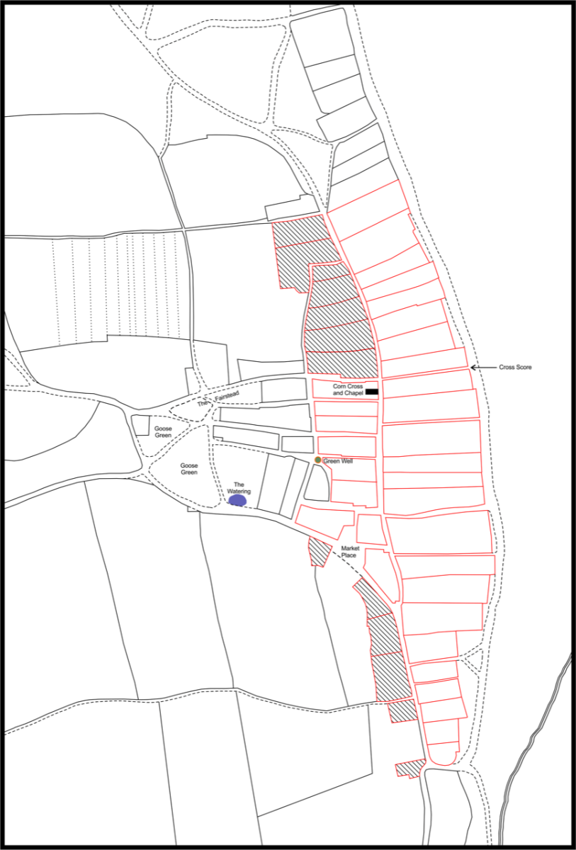
map created by the writer and his friend and fellow local historian, Ivan Bunn, showing the basic layout of the relocated township in red outlines. Seven named key features have been indicated and close study of the map will reveal the street-plan of today - even without the road-names being present. The cross-hatched areas represent freehold land; the unshaded ones copyhold
CREDIT: David Butcher
United Kingdom
Add new comment