
1400s
One of the most interesting features of local landscapes during the Late Medieval and Early Modern periods in any community (and Lowestoft was no exception) was the presence of areas not used for agriculture – usually because the soil was unsuitable for crops or too difficult to work, for one reason or another – and being generally referred as either common or waste. The former term referred to the land being available to people for various kinds of use and the latter derived from the Latin word vastus, meaning “empty” or “open”.
Added: 19 May, 2026
Faith and Duty opposing Earthly Ambition - A Local Story
Introduction
Added: 17 April, 2026 - a modern construction of a 14th century Hanseatic cog, found buried in the River Weser’s mud in 1962.")
Introduction
Great Yarmouth’s attempted dominance of Lowestoft and control of the latter’s trade only came to an end during the second half of the 17th century, when its legally backed dominance was ended and the Suffolk town placed beyond its jurisdiction.
Added: 7 December, 2025 - Suffolk Archives (Ipswich), Acc. No. 193/2/1.")
Introduction
The Church of England, as it stands today, is an organisation which originated in the need for a Tudor monarch (Henry VIII) to produce a male heir and secure his family’s tenure of the Crown and which then became part of a North European, Protestant, theological revolution. It is currently undergoing one of its periodic phases of change.
Added: 4 December, 2025
Reasons for the move
It is perhaps unwise to single out any one particular event in the life of a community over a period of about 1,500 years as being the crucial or formative one (other than its founding), but there is a good case for doing so where Lowestoft is concerned.
Added: 26 November, 2025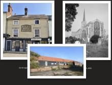
In some ways, buildings are every bit as much historical documents as written sources and can inform the observer of many aspects of human activity in days gone by. Where they have survived in original form, they have much to say of former economic and social conditions – be they domestic, ecclesiastical or industrial in nature. And, if altered and converted at different times, there is just as much to be learned from them. Let us take three of Lowestoft’s buildings, covering these three categories, and consider each one of them in turn within its context.
Added: 18 September, 2025
The foundation called the Good Cross Chapel is a lesser-known part of Lowestoft’s religious history, which once stood in the extreme south-eastern corner of the parish near the junction of the present-day Suffolk Road with Battery Green Road – possibly in the location of what is now the Fish Market entrance.
Added: 15 September, 2025 - Suffolk Archives (Ipswich), 193/2/1.")
Formal recognition of Lowestoft’s status as a trading port might never have been given in 1679, had the town not managed to free itself from Great Yarmouth’s claim to control all maritime traffic in local waters – especially that connected with the herring trade. Articles relating to this long-running and contentious issue are to be found elsewhere in LO&N’s History pages (The Lothingland-Lowestoft-GreatYarnouth Disputes (Parts 1 & 2) and a summative comment can be added to this.
Added: 1 June, 2025
The first almshouses in Lowestoft were provided by John Manyngham, the parish vicar from 1457-78. The exact year of institution is not known, but they were located on the north side of Fair Lane (now Dove Street) near its junction with West Lane (now Jubilee Way). And they seem to have remained in operation, in some form – undoubtedly with alterations made – into the final quarter of the 19th century, when White’s Directory of Suffolk (1874), p.
Added: 19 January, 2025
Much is heard today regarding illegal immigration into the UK from across the English Channel and occasionally the North Sea - most of it driven by difficult and dangerous conditions in the particular home countries of origin or by the perceived opportunity to start a more financially rewarding lifestyle than is possible in those same nations.
Added: 26 May, 2024