
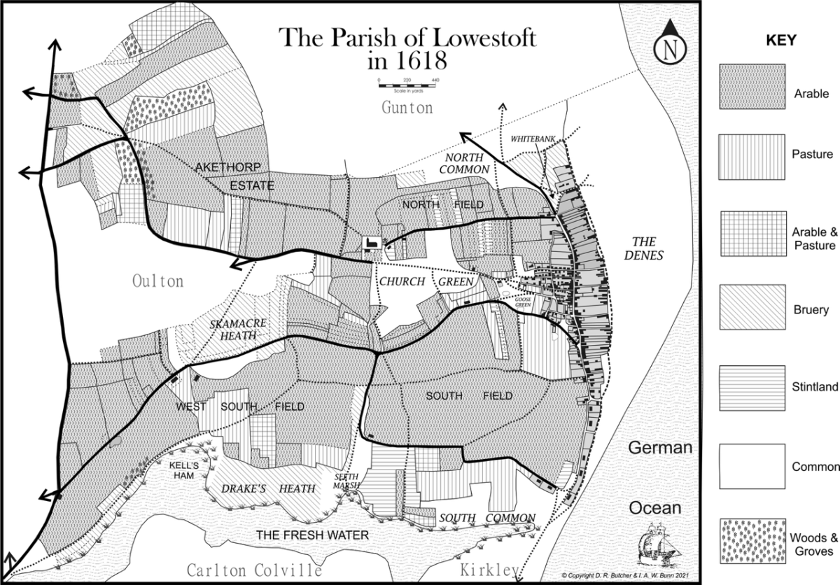
The Seven Commons of Lowestoft (14th-19th century)
One of the most interesting features of local landscapes during the Late Medieval and Early Modern periods in any community (and Lowestoft was no exception) was the presence of areas not used for agriculture – usually because the soil was unsuitable for crops or too difficult to work, for one reason or another – and being generally referred as either common or waste. The former term referred to the land being available to people for various kinds of use and the latter derived from the Latin word vastus, meaning “empty” or “open”. It had nothing to do with the ground having no value of any kind.
Quite the reverse, in fact. Common (which became very much the term in general use) was a valuable communal resource, which was strictly controlled by manorial practice and from which the lord derived a regular income. In light land areas, such as Lowestoft – and with much of the Suffolk coastal fringe, from Gorleston down to the Orwell estuary, consisting of a broad belt of heathland once known as the Suffolk Sandlings – a major use was for the rough grazing of livestock.
With the main types of vegetation being scrub grasses, bracken, heather, gorse and broom, blackthorn, hawthorn and dwarf birch, not only was this activity carried out – but other ones, as well. Things like the harvesting of dead bracken for animal bedding, the gathering of small firewood, the cutting of gorse to heat ovens and the use of sedge and rush (from damp areas) for thatching and floor-covering. In certain cases, where pockets of clay or sand were present, the digging of these was permitted – but, generally speaking, breaking the surface of the ground was not allowed. And all legitimate uses had small fees attached to generate income for the lord of the manor.

The seven areas of common land in Lowestoft, during the Late Medieval and Early Modern periods can now be identified and described.
1. The Denes
The largest of all, by far, was the area between Whaplond Way (Whapload Road) and the shoreline, which a Manor Roll of 1618 – Suffolk Archives (Ipswich), 194/A10/73 – shows to have been around 200 acres in area. This, owing to the process of sea erosion, would already have been less extensive than it had been in May 1545, when a military survey of coastal defences carried out by Thomas Howard, Duke of Norfolk, measured the Denes as 1,000 yards in width – this, compared with the 200 or so present today. The Manor Roll referred to was a detailed survey and description of all lands and buildings in the parish, giving ownership, location and size.
The name denes itself is a variant of dunes, deriving from Old English dūn, meaning “a hill”, and referring to the undulating nature of many sanded areas of beach. And it seems to have become applied to such coastal sandhills during the Late Medieval period, with the first known written or printed source dating from the year 1523. It is likely in Lowestoft’s case – and in other similar local areas – that the undulation of the ground bordering the sea was never very pronounced because of tidal action and the effect of the wind. And the progressive development of scrub-growth of one kind and another on its surface would have moderated this even further.
The Denes area was of mixed use, serving to provide rough grazing for livestock (sheep, cattle and horses) and as a large open-air wharf before the harbour was built during 1827-30. Shipping anchored up in the offshore haven, between the Holm Sand and beach, and cargoes of all kinds to do with fishing and maritime trade (both inward and outward bound) were carried by ferry boats from and to the waiting vessels. Another important maritime-related activity was use of the area for the drying, repair and maintenance of fishing nets – these being spread out on the scrub vegetation, to aerate them and keep them above ground level. Part of the treatment of hemp-fibre drift-nets (used to catch herring and mackerel) was periodic soaking in linseed oil.
References to net-maintenance are to be found in the last volume of Robert Reeve’s four-part hand-written manuscript ‘A History of Lowestoft and Lothingland’ (c. 1810) – Suffollk Archives (Ipswich), 193/3/1-4 – p. 203. Reeve was a local solicitor and steward of the manor, and a meticulous recorder of Lowestoft’s past. He reveals that townsmen were allowed the privilege of net maintenance free of charge, but that fishermen from others parts of England (mainly Kent and Sussex) paid 1s 4d for the autumn herring season and foreigners (mainly Dutch) 2s 8d.
One of the plants growing wild on the Denes was the Sea Pea (Lathyrus japonicus) and this provided local people – especially the poorer members of society – with an edible vegetable. To the point, where Lowestoft folk were sometimes found referred to as “Pea Bellies” during the 18th and 19th centuries. However, any attempt to catch the rabbits which inhabited the Denes was not allowed and in 1712 Charles Boyce of Gunton (a leading local farmer) was fined the sum of 5s in the annual Leet Court –which dealt with infringement of manorial rules – for doing so. The animals were not only useful as a source of food, but their skins had value through being used to form the felt used in making hats.
Further tight control of the area (exercised by the manorial steward, in the absence of a resident lord) is to be seen in the fact of no building being allowed to take place there – until the late 18th/early 19th century. The digging for sand and gravel was also prohibited and a 3d fine imposed in the Leet Court on anyone found doing so. One type of excavation, however, had been permitted at some point (probably during the 16thcentury) in the northern sector of the Denes: a large trench running north-south, around 100 yards in length, in which cod livers brought back from the Iceland lining voyages were boiled down to produce the so-called train oil used to fuel household lamps and treat newly made leather. This feature has been written about, in its own right, elsewhere in the History pages of LO&N.
The one area of activity not seen to directly by manorial procedure was the maintenance of drainage ditches present on the Denes. At some point, this matter had been placed into hands of the two parish Churchwardens, who also had repair and upkeep of the Scores added to their civic duties. Both matters are round referred to in surviving Churchwardens Accounts for the years 1714-36, with expenditure made to address what needed doing. And the recorded proceedings of the annual Leet court, dealing with infringement of the manorial rules and civic misdemeanour, show them fined regularly for being in breach of their responsibilities.
Shipbuilding and the construction of smaller craft took place along the shoreline (especially in the southern sector), just above high-water mark, and there are views produced during the 1780s by Richard Powles, a local artist associated with the Porcelain Factory, showing vessels under construction or repair. And another industry associated with the Denes during the late 18th century, and for a good deal of the 19th, was rope-making. The open nature of the area was ideal for this activity and rope-walks were to be found on a north-south alignment. A major one in the northern part one ran down the middle, from opposite the Sparrow’s Nest Gardens down to the Birds Eye Factory site. It was known as Gowing’s Ropewalk, after the man who operated it for many years.
As was stated, three paragraphs above, The Denes area was kept free of building-work until the late 18th/early 19th century, when the first houses began to appear at the southern end – possibly as the result of an increasing population, The sporadic development continued on a modest scale, until a sudden and definite growth in numbers was caused by the coming of the railway and development of the harbour works by Samuel Morton Peto during the 1840s and 50s. Eventually, the so-called Beach Village was created with a structured, grid-pattern layout of streets – though most local people referred to this particular part of town as “The Grit”. It remained in use up until the Second World War, but was progressively demolished during the 1950s and 60s as part of urban improvement schemes and became a small industrial estate.
The northern part of the Denes remained relatively unbuilt, compared with its southern counterpart, and net-drying remained an important function in one particular location which has survived down to the present day. The Spars, as they were known, were wooden frames constructed for the drying of drift-nets, particularly, and also for ropes of different kinds – both after use at sea and also following preservative treatment on shore. They were first erected probably from the middle of the 19th century onwards, as both drifting and trawling expanded as the result of harbour extensions and improvements and the establishment of railway links. The few remaining ones seen today are the lineal successors of their predecessors and many of the uprights are recognisable as split redundant railway-track sleepers, while the horizontals are mainly re-used telegraph poles.
The posts and their crossbars are a significant part of Lowestoft’s fishing heritage, both practically and visually, and the remaining ones are historically important – especially when taken in tandem with the net stores which stand opposite, further down, on the opposite side of Whapload Road. Together, they form a working environment whose purpose is largely lost upon people today and which is mainly accessible through looking at old photographs and postcards.
2. North Common
This area was probably mainly used for rough grazing of livestock, occupying the ground-space now largely taken up by Belle Vue Park and the top ends of Park Road, Royal Avenue and Sussex Road – running acrossto the allotment area next to Ormiston Denes High School. Very little documentation relates to it and what there is mainly concerns much of its surface area being converted to the attractive public gardens which are seen today.
The creation of Belle Vue Park (with the name chosen, to give an air of French elegance) came about during the 1870s, as part of a plan for civic improvement and the provision of public amenities. But it was triggered in part by concern, on the part of the Town Commissioners (there being no Borough Council in place until a royal charter was granted on 31 August 1885) that the area had become a gathering-lace for those townspeople – almost certainly largely male – disposed to idleness and misdemeanour. And, so, a scheme was put in place to turn a large part of it into a place of polite resort and amenity. Gunton Score was re-named the Ravine (a title suggestive of naturalistic and romantic landscape) and the new area of formal gardens was opened to the public in the year 1874 – complete with caretaker’s rustic thatched cottage. Where the “idlers” resorted to after that is not known!
During the 1890s, the Borough Council purchased thesmall, adjacent, foot-of-cliff seaside estate once belonging to the Sparrow family of Worlingham Hall, near Beccles – one of whom, Robert (1741-1822) had built a picturesque cottage there and laid out attractive garden grounds. Under the name of Sparrow’s Nest,with Belle Vue Park above, this added greatly to the attractions of the North Denes part of town.
3. Goose Green/Fair Green
This was the smallest of Lowestoft’s areas of common land, situated on the western edge of the Late Medievalplanned township of the first half of the 14th century. It occupied the ground space now centring on St. Margaret’s Plain – taking in the bottom ends of Park Road, Queen’s Road and Cambridge Road to the north and St. Peter’s Street (once known as Beccles Way) to the south, thereby covering Factory Street, Elim Terrace and Thurston Road. Boston Road (as it later became) marked the western limit, while Mariners Street, Compass Street, Dove Street and Crown Street Westmerged into it on the east – these roadways once being known as Swan Lane, Tyler’s Lane, Fair Lane and Bell Lane.
As the name of this small common indicates, the area was of dual use – though where the demarcation was is not specifically stated anywhere. It seems as if it wasprobably along the line of Bell Lane, with this southern sector given over to the grazing of geese. It was the only part of town where this was allowed and, if anyone’s birds were found straying anywhere else, a fine of 2d per goose was imposed – this measure having been established by a Leet Court ordinance of 1582. Geese graze effectively on grass, being kept for producing both eggs and meat, and would almost certainly have been tethered by collar and pegged line – and with their primary flight feathers clipped to prevent aerial movement. Their droppings were messy and it would have been necessary to keep them off the northern part of the common, where the annual fairs were held.
The town’s pound, for the confinement of straying livestock, stood on Goose Green at what is now the junction of Factory Street with Thurston Road. And there was a further connection with such animals in the presence of a large pond, known as The Watering, located at what is now the junction of Thurston Road with the fenced-off section of St. Peter’s Street. Use of this was strictly controlled, so as to avoid pollution, and the dumping of rubbish and waste into it was strictly forbidden – as was the soaking of bundles of hemp, prior to crushing the stems for retrieval of the fibres. It was also where the town’s ducking-stool was located, during the 16th, 17th and 18th century – before such implements of public punishment and humiliation went out of use
Fair Green, of course, was clearly the venue for the holding of the annual fair dedicated to the town’s patron, St. Margaret of Antioch (now Antakyah, in southern Turkey, near the border with Syria) – an apocryphal 5th century Christian martyr. It was grantedby the Crown to the lord of the manor, John de Dreux (Earl of Richmond and Edward I’s nephew) in 1308 – along with the right to hold a weekly (Wednesday) Market – and was an eight-day affair, beginning on the vigil of St. Margaret (19 July). This was superseded in December 1445 by a re-grant to William de la Pole (Marquis of Suffolk), allowing two fairs to be held: on the feast day of St. Philip & St. James (1 May) and on that of St. Michael & All Angels (29 September), with three celebratory days on either side of each festival.
No records seem to have survived regarding the conduct of the Lowestoft fairs, but Edmund Gillngwater reveals in his published history of the town (1790), p. 55, that in 1768 Sir Ashurst Allin – lord of the manor, at the time – allowed the townspeople (upon request) to move the fairs from the Green onto to the formersubsidiary market place on the south side of Tyler’sLane (Compass Street) at its junction with the High Street. Which suggests that the fairs had declined in importance and no longer required such a large area as the original venue.
Fair Green – or The Fairstead, as it was often referred to – was the area to the north of Bell Lane (Crown Street West), occupying St. Margaret’s Plain and the bottom ends of Park Road, Queen’s Road and Cambridge Road. Dove Street, as we know it, was once known as Fair Lane and also (later) as Almshouse Lane because of charitable housing which formerly stood on its northern side. Originally, the roadway consisting of Compass Street and Dove Street was called Bier Lane, which suggests that this was the route by which corpses were once carried to St. Margaret’s Church for burial. It linked directly with a track crossing Church Green (known as the Church Way) and conveyance of the dead – mainly shrouded and uncoffined during Late Medieval times – would have been both direct and convenient.
4. Church Green
This extensive area of common land was situated to the west of Fair Green/Goose Green and occupied much of the ground-space between what is now Boston Road to the east and Rotterdam Road to the west, and St. Margaret’s Road to the north and St. Peter’s Street to the south. It had obviously been a larger entity at one time, but substantial encroachments along the northern and southern sectors had seen the land converted to agricultural use. A footpath known as Church Way ran clean across the middle, carrying on from Fair Lane,and remains in use today as Church Road.
Unlike the other six areas of common land in Lowestoft, Church Green had at some point in the past been released completely from manorial control and placed in the hands of the two parish Churchwardens. They were made responsible for keeping it in good order and seeing that its boundary hedges were well maintained, that at least one bridge over a watercourse that crossed it from north to south was kept in repair, and that noxious weeds were removed from its surface. Such shift in the devolvement of duties – along with those of seeing that the Scores were well maintained, that the communal Green Well and Basket Wells were always usable, and that the drainage ditches on the Denes were functional – may have been carried out to free the manor of regular expenditure and place the burden elsewhere. Though it was widely done throughout England to give Churchwardens responsibility for highway maintenance.
The matter of removal of noxious weeds related directly to Church Green’s main use, which was to provide grazing for the town’s cattle. It is found referred to as “the common cow pasture of Lowestoft”, which shows that milk production was central to its purpose and function, and also that it indicates something of how the town’s farming practice was carried out during the Early Modern period. The old Late Medieval system of communal, strip-layout, agricultural function – operating on the three open fields (South Field, West South Field and North Field) – had largely gone out of use, with the land parcelled up into smaller, mainly enclosed areas. But the ten to twelve nucleated farmsteads, dispersed around the parish, to be seen on the Tithe Apportionment map of 1842, did not exist – being the result of late18th/early 19th century Enclosure Acts.
Before this process had taken full effect, farming in Lowestoft operated from out of town on a daily basis, with those men involved at varying levels of activity (large and small) going out each day, or sending their workers, to carry on the work needed for growing crops or tending livestock. Although fishing and maritime trade were the main parts of Lowestoft’s economic activity, farming was also an important element in creating food for its population and also the materials used in two of its important local industries, brewing and leather production. Most of the corn grown was barley and cow-hides were the staple material in the tanning process.
The name of Church Green has been retained for that part of its surface-area nearest to St. Margaret’s Church, which was developed in 1964 to provide affordable, social, retirement housing for people over the age of sixty. Nos. 1-56 Church Green (just off St. Margaret’s Road) consist of bungalows and two-storey flats, designed by local architects Tayler & Green – a practice which became well known for its imaginative rural housing terraces created for Loddon Rural District Council during the 1950s and 60s. The work carried out in Lowestoft is also notable for its quality of design, as well as for preserving the name of a major landscape feature from the town’s past.
5. Skamacre Heath
This particular area has also had its name perpetuated in an area of housing development dating from the 1960s. It was formerly a stretch of heath which straddled Beccles Way (now Normanston Drive) – incorporating the High Beech section of today –bounded by Northgate on its eastern edge and Fir Lane on the west, the latter being a track which ran across both it and its continuation into Oulton parish. Its northern limit would have been the Evans Drive area and its southern one the Skamacre Crescent area itself.
The ground was of dual use for grazing livestock. Part of it (to the south of Beccles
Way and on its westernmost extremity) was open common. But the majority was parcelled up and rented for a given period as bruery – managed heathland, either staked out in strips or fenced off into small enclosures. Any gorse growing on it would have been used as fuel (especially to heat ovens) and dead bracken mown for animal bedding. It might even have been possible to have harvested small amounts of low-grade hay, depending on what species of grass grew there.
The word skamacre itself may have developed from two elements – the second one (acre) not referring to that particular measure of land-area, but to an Old English word meaning a field in general terms. While the first component (skam) is possibly a variant of skim –referring to the light nature of the soil having insufficient depth and quality to have been of use for agriculture, Therefore, it may have been the case that, at some point during the Late Medieval period, an attempt had been made to cultivate this area – only to find that it was unsuitable for growing crops.
6. Drake’s Heath/Smithmarsh
Although giving its name to a residential road to the south of Skamacre Cresent (along
with Robin Hill, Field View Drive and South View Close), most of this particular area was agricultural land forming part of the one-time cultivated West South Field. Drake’s Heath itself was located further to the south, bordering the northern shore of the Fresh Wateror Great Water (as it was once referred to) – later to become known, during the earlier part of the 19thcentury, as Lake Lothing.
Most of it is now covered by Barnard’s Meadow, the North Quay Retail Park and the most easterly part of Peto Way. The first element of the name is lost in the mists of time, but it may have been the surname of someone who had a particular connection with the area sufficient enough to become associated with it. Most of the area was used for managed grazing, being set out as bruery in strips on a north-south alignment – with most of these being around two acres in area. One of them – the narrowest of all at half-an-acre – is recorded in the Manor Roll of 1618 as having a mound present, which might well have been a burial monument of the Bronze Age period.
The Smithmarsh area was located directly to the east of Drake’s Heath, covering what is today the southern part of Rotterdam Road, from its junction with Norwich Road down to Lake Lothing itself – encompassing the approaches to the Gullwing Bridge, the western end of Denmark Road, and the Hervey Street/Stevens Street/Selby Street/Clemence Street area. The term Smithmarsh had nothing to do with anyone’s surname. It was a corruption (or variant) of Seethmarsh, which probably originally referenced the presence of standing water there – close to Lake Lothing’s edge – being agitated and rippled by the wind.
A fall in water-levels, at some point, had probably ended this – but the area remained somewhat boggy in nature and formed what was known as stintland. This was, again, a type of managed grazing for livestock – stint being a Late Medieval/Early Modern term for limiting the pasturage of common land to a certain, specified number of cattle. It derived from Old English styntan, meaning “to stop”, and by 1513 (as first recorded in a written or printed source) come to indicate setting bounds to something or limiting something in extent. Which meshes in perfectly with grazing land being set out in measured units and being hired for use for a stipulated period. Blending into the southernmost sector of the cultivated and once stripped-up South Field, the easternmost part of the area is actually found referred to in the 1618 Manor Rollas Seethmarsh Field.
One of the very few houses in the parish, to be situated out of the main part of town, was Smithmarsh Farm – known as Pope’s Farm by the late 19th century – which stood on the north side of the junction of Chapel Lane(now Norwich Road and Bevan Street West & East) with Hercote Way (now the bottom end of Rotterdam Road).The former roadway ran to the Good Cross Chapel, which stood somewhere in the general area of where the Fish Market entrance is now located, providing a route to this wayside shrine from the township’s earlier site before it relocated to the cliff-side during the first half of the 14th century. The name Hercote may possibly have referred to the practice of hunting (coursing) hares with two dogs working together andwith the damp grassland environment providing suitable habitat for the hares themselves.
Smithmarsh Farm itself has quite as lot of information relating to it, dating from the early 18th century and relating to the man who was working it at the time. Robert Lilly had only been in occupancy for no more than eighteenth months, when he died of smallpox in April 1711. Parish tithe records show that his farming enterprise included the growing of turnips (to feed cattle) and the keeping of geese and ducks, while his probate inventory reveals that his livestock consisted of one cow, four heifers, six horses (two of them old) and six pigs. He was also growing hemp and had a tow comb, used for combing its fibres into the material used for spinning into the yarn needed to make twine and coarse linen.
The farmhouse itself had ten rooms (plus a backhouse, used for general storage and washing clothes) – one of which was a dairy housing milk-containers of various kinds, with cheese stored in the chamber above. There was a hall (which had cooking facilities), a parlour(probably used as “best room”), two butteries (used for storage and eating), a pantry and four chambers(bedrooms) – the one above the dairy already having been mentioned. A buttery was a service-room – usually next to a kitchen, if there was one, and acting as a substitute if there wasn’t one designated as such – which was used for the storage of drink, bread, butter and cheese. It derived from the Old French word boterie.
All of this information shows farming which was geared to damp land practice. The keeping of geese and ducks mainly for their eggs (with some culling for meat), the production of milk for cheese-making, the cultivation of hemp, the proximity to what may be described as “semi-marshland” used for grazing, and the growing of turnips as cattle-feed. All of these show that Robert Lilly (wherever he had come from) was orientated towards animal husbandry rather than a mainly arable way of farming. On the evidence of the details relating to him, he was just settling into a new enterprise when the most dreaded disease of the time struck him down. At sixty acres or so, Smithmarsh Farm was at the upper end of the size generally reckoned as being of medium proportions in England at the time (thirty acres being the lower limit). Lilly had probably moved into his new farm with high hopes of doing well and building up a dairy herd from his heifers, but he had no more than eighteen months there before he died.
7. South Common
This was located along the northern edge of the Fresh Water/Great Water (Lake Lothing), occupying what is now the eastern end of Denmark Road and neighbouring railway track, the Railway Station and Station Square, and Commercial Road. No specific information has been found regarding it in earlydocumentation relating to the town, other than descriptions of it as common pasture in the 1618 Manor Roll – when other units of land abutting onto it are being recorded and described. These references show that it was used for the rough grazing of livestock, but that is about as much as can be said about it. The surface area was greatly extended during the early 19th century, when a block of heathland belonging to the parish of Kirkley was apportioned to Lowestoft by the 1801 Enclosure Act (implemented in 1803) – covering the area now occupied by South Quay Retail Park, Belvedere Road, St. John’s Road, Mill Road, the bottom of London Road South and Marine Parade.
United Kingdom
Add new comment