
early modern

What you see is the remains of the base of a beacon, one of a pair erected in 1552 (on the orders of the Marquis of Northampton), to warn of attack from the sea. Its companion was located just to the north of what is now the junction of Gunton Drive with Corton Road.
Added: 22 September, 2023
Taken from volume II (pp. 1412-19) of Isaac Gillingwater’s three-volume handwritten manuscript ‘A History of Lowestoft and Lothingland’ (c. 1800-10) – Suffolk Archives, Ipswich, 193/1/2&3. A local barber and wig-maker, he was the older brother of Edmund Gillingwater and lived in a house on the northern side of Tyler’s Lane (Compass Street).
Added: 14 October, 2026
A number of rules and fees payable (applying to both residents and outsiders) surviving from the Late Medieval and Early Modern periods is to be found in documentation relating to the town, with Robert Reeve’s handwritten, unpublished ‘A History of Lowestoft and Lothingland’, vol. 4 (c. 1810) – Suffolk Archives (Ipswich), 193/3/4 – being a main source of information. A practising local solicitor, he was also Steward of the Manor during the late 18th and early 19th century and therefore well placed to be familiar with various aspects of its day-to-day running.
Added: 29 September, 2026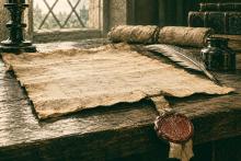
It is stated in the Book of Fiefs/Fees (al. Liber Feodorum) – an Exchequer listing of feudal estates compiled at the beginning of the 14th century – that Lowestoft was a manor in its own right by the year 1212. This possibly being when its status was raised from that of mere outlier to the Lothingland Half-hundred manor (as recorded in the Domesday Survey of 1086), whose hub was Gorleston.
Added: 28 September, 2026
Former Names for Lowestoft Streets, Roads and Scores
All of the older names listed below in italic font derive from documentation of one kind or another relating to the town – particularly those manorial records recording the transfer of property 1582-5 & 1616-1756, to the Revd. John Tanner’s transcriptions of these done up until 1720-25, and to the Manor Roll of 1618. All found as Suffolk Archives (Ipswich), 194/A10/4, 194/A10/ 5-19, 454/2 and 194/A10/73.
Added: 20 June, 2026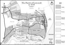
One of the most interesting features of local landscapes during the Late Medieval and Early Modern periods in any community (and Lowestoft was no exception) was the presence of areas not used for agriculture – usually because the soil was unsuitable for crops or too difficult to work, for one reason or another – and being generally referred as either common or waste. The former term referred to the land being available to people for various kinds of use and the latter derived from the Latin word vastus, meaning “empty” or “open”.
Added: 19 May, 2026
The pages reproduced below, in as near as possible their original format, are to be found in volume 3, section 4, of Robert Reeve’s four volume manuscript ‘A History of Lowestoft and Lothingland’ (c. 1810) – Suffolk Archives (Ipswich), 193/3/4. Nothing is recorded for the years 1719, 1722, 1728 and 1733. Reeve (a local solicitor), who lived at No. 49 High Street, was steward of the manor and he must have transcribed this material from an original source of some kind.
Added: 2 March, 2026
This fascinating document records settlement of the estate of a leading Lowestoft merchant, whose burial was recorded in the parish registers on 18 September 1636. It is located within the pages of the Lowestoft Tithe Accounts book (Norfolk Record Office, 589/80) – placed there by the Revd. John Tanner (Vicar of the parish, 1708-59), who had married into a branch of the Mighells family on 20 January 1713 (1712, by Julian Calendar dating) and who probably found the document among existing family papers. He obviously noticed, in the second set of accounts, that burial within the walls of St.
Added: 1 February, 2026
The national Muster Roll of 16 January 1584 (1583, by Julian Calendar reckoning) was a head-count of all adult males in England between the ages of sixteen and sixty, taking into account their military capability in terms of the weapons they held. It was carried out in anticipation of a possible Spanish invasion, launched across the North Sea from the occupied Netherlands (see Lothingland Invasion Scare of 1584,elsewhere, in the History pages of LO&N).
Added: 19 January, 2026
The national Muster Roll of 23 May 1535 was ordered by Henry VIII to take stock of England’s military capability, in terms of the country’s able-bodied adult males and the weaponry they possessed (there being no standing army of any kind) – this in anticipation of possible invasion from abroad, with a coalition of France and Scotland seen as being the likely source of aggression.
Added: 2 January, 2026