
1600s

All of the older names listed below in italic font derive from documentation of one kind or another relating to the town – particularly those manorial records recording the transfer of property 1582-5 & 1616-1756, to the Revd. John Tanner’s transcriptions of these done up until 1720-25, and to the Manor Roll of 1618. All found as Suffolk Archives (Ipswich), 194/A10/4, 194/A10/ 5-19, 454/2 and 194/A10/73.
Added: 20 June, 2026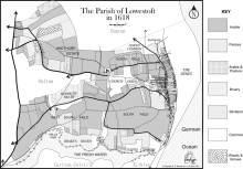
One of the most interesting features of local landscapes during the Late Medieval and Early Modern periods in any community (and Lowestoft was no exception) was the presence of areas not used for agriculture – usually because the soil was unsuitable for crops or too difficult to work, for one reason or another – and being generally referred as either common or waste. The former term referred to the land being available to people for various kinds of use and the latter derived from the Latin word vastus, meaning “empty” or “open”.
Added: 19 May, 2026
Reasons for the move
It is perhaps unwise to single out any one particular event in the life of a community over a period of about 1,500 years as being the crucial or formative one (other than its founding), but there is a good case for doing so where Lowestoft is concerned.
Added: 26 November, 2025. Allin’s ship, the “Plymouth”, is shown flying its red flag below his right hand. Samuel Pepys. saw the overall work of portraiture under way in Lely’s studio during April 1666")
17th & 18th Century Naval Commanders
It is a claim – not made lightly by this writer – that no town of its size, in the whole of England, produced as many eminent top-rank Naval commanders as Lowestoft did between 1660 and c. 1720. During that time, no less than four admirals and five captains came from five local families mainly involved in fishing and maritime trade: the Allins, the Arnolds, the Ashbys, the Leakes and the Mighells.
Added: 21 November, 2025 has the Gurneys, Birkbecks, Barclay and Buxton Bank located there, under the management of Henry Leman")
Provision of credit in the community
The importance of scriveners as community bankers in London during the second half of the 17th century has been noted, as has their role as providers of funds elsewhere. Nor has the function of the goldsmith escaped attention. Lowestoft, being a town of modest size, had few named scriveners among its inhabitants (no more than six or seven have been identified between 1560 and 1730) and most of them had other occupations.
Added: 20 November, 2025
An Inventory of all and singular the goods and chattels, rights and credits, of Elizabeth Pacy late of Lowestoft in the county of Suffolk, widow, deceased, valued and apprized by John Wilde, Henry Warde, Samuel Smyth, John Aldred, John Fowler and James Pacy the 18th day of August Anno. Dm. 1682 as followeth vizt.
Added: 28 October, 2025 advertised the “Queen’s Head” premises, halfway down Tyler’s Lane (Compass Street) on the south side. Taken from the Isaac Gillingwater collection of illustrations (c. 1807): Suffolk Archives (Ipswich), 192/3/1.")
Inns
The configuration of roads and the importance of land transport have always been major influences on the development of towns and their inns. Large yards were necessary for stabling horses, and for standing carts and carriages; buildings were required for storing hay and other forage; and provision had to be made for watering the animals. Adequate accommodation was also needed for those people making overnight stops or staying in a place for longer.
Added: 18 October, 2025
Lowestoft Houses – 16th-18th Century
The most commonly mentioned items of interior decoration during the later part of the 16th century, in the houses of the merchants and the better-off tradespeople and craftsmen, are stained or painted canvas cloths. These served to decorate the walls on which they hung and they probably also served as draught-inhibitors. They were present in bedchambers, as well as in halls and parlours, but no indication is given as to whether they had scenes depicted upon them or whether they were simply covered in patterns.
Added: 5 October, 2025
A small house (early 18th century)
John Cousens (carter) lived with his wife Mary in a three-roomed house somewhere in the side-street area to the west side of the High Street. Their son, Benjamin (aged twenty-four years) had left home, but their daughter, Mary (aged twenty years) was possibly still living there. When the inventory of Cousens’s goods was made on 6 June 1711, his total estate was valued at £73 8s 9d. Out of this sum, £50 consisted of good debts and a further £16 17s 0d. of his working equipment and horses.
Added: 5 October, 2025
Construction details
In May 1545, the Duke of Norfolk was carrying out a review of coastal defences between Great Yarmouth and Orford because of a perceived invasion threat from France. Having commented on the hostile landing capacity of both anchorage and beach at Lowestoft, as well as on the positioning of the three small gun batteries, he made the following remark concerning the place itself: “The town is as pretty a town as I know any few on the sea coasts, and as thrifty and honest people in the same, and right well builded.” – ref.
Added: 24 September, 2025