
Late Medieval

When Henry III died in November 1272, his son and successor Edward (thirty-three years old) was in Sicily, on the way home from fighting in the Seventh – and last – Crusade. A hardened warrior of many years experience, it wasn’t until the year 1274 that he finally reached England to take up his throne, with the coronation being held in Westminster Abbey on 19 August. He went on to subjugate Wales, invade Scotland (becoming known as “the Hammer of the Scots”) and generally impose his presence on all around him – his impressive height of 6’ 2” gaining him the nickname of “Longshanks”.
Added: 31 August, 2024
Much is heard today regarding illegal immigration into the UK from across the English Channel and occasionally the North Sea - most of it driven by difficult and dangerous conditions in the particular home countries of origin or by the perceived opportunity to start a more financially rewarding lifestyle than is possible in those same nations.
Added: 26 May, 2024 - half a mile or so wider during the 1660s than it is now. Location of the post which marked the limit of Yarmouth’s trading jurisdiction, established in 1663")
“All Because of the Herring”
The first part of this extended article (Suffolk Review, Spring 2020) dealt primarily with the commercial and civic contention between Great Yarmouth and its nearest neighbours on the Suffolk side of the River Yare: Gorleston and Little Yarmouth.
Added: 13 April, 2024
“All Because of the Herring”
Great Yarmouth’s disputes with its near-neighbours in Suffolk, during the Late Medieval and Early Modern periods, are generally well known in outline – if not in detail. The following series of notes (summarised, by the writer, from the sources cited) relates to the long-running conflict between the Norfolk borough and its Suffolk neighbours, regarding the former’s legally granted ommercial rights and its control of the local herring-trade.
Added: 13 April, 2024
Compass Street originally formed one track with Dove Street - known as Bier Lane during the 14th century, because it was the track by which corpses (placed on a hand-bier) were taken from town for burial in St. Margaret’s churchyard. The track extended westwards over Church Green, more or less following the line of what became - much later on - Wesley Street and Church Road. During the 16th and 17th century, the named changed to both Fair(stead) Lane and Almshouse Lane, since the annual fairs were held on Fair Green (which is the St.
Added: 8 April, 2024
Recorded on Suffolk Heritage Explorer (Internet) as Monument record LWT 368.
Centring on OS 1:25000 Series Map reference TM59 539939.
Added: 18 March, 2024
Lowestoft
The Domesday Survey details (1086) relating to these two communities have been presented and examined in another article, so there is nothing to be gained from repeating what was said there. What can be usefully done, by way of follow-up, is to look at what is known of their function during the centuries following on from William I’s great audit of his realm and reveal something of their manorial status and history.
Added: 13 March, 2024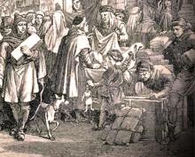
Lothingland
The original grant of a market in Lothingland Half-hundred was made by King John in the year 1211 – three years after Great Yarmouth had received its charter of incorporation (March 1208) with specifically stated preferential trading rights in its own local area. With Crown income solely in mind, the monarch either had no idea of the contention and strife these opposing privileges would cause or was not concerned about them in any way.
Added: 26 February, 2024
When the Lowestoft township relocated itself onto the cliff-top during the first half of the 14th century, it had considerations to take account of other than the demands created by its inhabitants’ domestic requirements (these being mainly concerned with the terracing of the cliff to make it usable, the laying out of house-plots and a road system, and the management of the scores to give access to the beach and Denes).
")
Produced to assist with the building’s regeneration and future uses
1. The Lowestoft community relocated itself (onto what is now the High Street area of a much expanded town) from what was probably its original location about a mile to the south-west, in an area now occupied by a large municipal cemetery between Normanston Drive and Rotterdam Road.
Added: 19 February, 2024